Limes (Roman Empire)
The remains of the frontiers today consist of vestiges of roads, forts, fortresses, walls and ditches, and associated civilian settlements.
[7] An etymology by Julius Pokorny in Indogermanisches Etymologisches Wörterbuch says that limes comes from Indo-European el-, elei-, lei-, "to bow", "to bend", "elbow".
[8] The first use of the term limes[9] as meaning "land border" appears for the first time in 98 AD by Tacitus:[10][11] ...nec iam de limite imperii et ripa, sed de hibernis legionum et de possessione dubitatum (...not only were the frontier of the empire and the banks [of the Danube] in danger but also the winter-quarters of the legions and the provinces).Its definitive use for the Danubian border seems to date from about 122 in the time of Hadrian:[12] Per ea tempora et alia frequenter in plurimis locis, in quibus barbari non fluminibus sed limitibus dividuntur, stipitibus magnis in modum muralis saepis funditus iactis atque conexis barbaros separavit (During this period and on many other occasions also, in many regions where the barbarians are held back not by rivers but artificial barriers, [Hadrian] shut them out by tall stakes planted deep in the ground and fastened together in the manner of a palisade).Some experts suggested that the Germanic limes may have been called Munimentum Traiani (Trajan's Bulwark) by contemporaries, referring to a passage by Ammianus Marcellinus, according to which emperor Julian had reoccupied this fortification in 360 AD.
Security and monitoring on the coasts in the west and southeast were achieved by forts and by chains of watchtowers or signal towers, both along the coastline.
In the 3rd century, a separate military district, the Litus Saxonicum,[citation needed] was established on the British side of the English Channel between the estuaries of the Wash and the Solent, to repel Saxon pirates and plunderers.
Monitoring and coastal surveillance were carried out by a chain of watchtowers or signal towers, forts and fortified ports (Gaul).
Each camp had its own river port or landing stage and a storage area, because the Rhine not only formed the border but was also the most important transport and trade route in the region.
The landscape of the third section between Ulpia Noviomagus Batavorum and Mare Germanicum (the North Sea) was characterised by numerous small streams and boggy marshland.
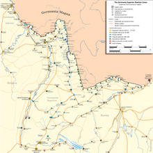
This limes existed from the 1st to 5th centuries AD and guarded the provinces of: It lay on the territory of the present German states of Rhineland-Palatinate, Hesse, Baden-Württemberg and Bavaria.
In its final stages, the Upper Germanic-Rhaetian Limes was about 550 kilometres long and ran from Rheinbrohl, in the county of Neuwied in northern Rhineland-Palatinate, as far as Hienheim on the Danube.
As early as the period 15 BC to about 70 AD, the border between Rome and Germania ran mostly along the line of the late antique Danube-Iller-Rhine Limes (DIRL) before the Romans advanced further north into the Agri decumates.
Because of troop withdrawals and massive barbarian invasions, the Upper Germanic-Rhaetian Limes were abandoned in the late 3rd century and the Roman forces pulled the border back to the banks of the three rivers.
Around 370 AD, the line of fortifications was considerably strengthened under the Emperor Valentinian I to counter the Alemanni, who were steadily advancing southwards.
By contrast with the Upper Germanic-Rhaetian Limes, the DIRL primarily fulfilled defensive purposes; its camps had much stronger and higher walls than their High Imperial predecessors.
Between the camps, in strategic places or good points of observation, were watchtowers or signal towers and, in the Late Antiquity, burgi.
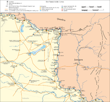
Here the narrow valley of the Wachau, with its densely forested escarpments, made access to the riverbank more difficult, providing some defensive function.
Every camp had its own river port or landing stage and a storage area because the Danube was not only a border zone, but also the most important transport and trade route in the region.
In the immediate hinterland of the limes, walled towns or municipia were founded – for example, Aelium Cetium or Ovilava (Wels).
The occupying troops, Exercitus Noricus, consisted mostly of auxilia cohorts and a legion stationed in Lauriacum/Enns acted as the strategic reserve.
Although this section of the frontier was relatively well protected by the Danube river border or Ripa, the Roman military presence here was always exceptionally strong (three military camps in Pannonia, but only one in Lower Pannonia) because especially after the abandonment of Roman Dacia in the late 3rd century, the pressure of migrant peoples from the east on this section of the limes intensified.
The initial wood and earth structures, were systematically converted under Emperor Hadrian into stone barracks and, in the 4th century, redesigned and massively strengthened in order to match new strategic requirements.
In late Roman times huge inland camps were built and towns in the hinterland were fortified to create a second line of defence.
In the time of Emperor Marcus Aurelius the first mention is made in Pannonia of stone watchtowers (burgi, panelled towers and fortlets (praesidia).
[15] Advance defences were provided by bridgehead camps (e.g. Castra Contra Aquincum or Celemantia) and military stations on main transport routes in the Barbaricum (e.g. near Musov).
[16] The Fossatum Africae ("African ditch") of at least 750 km controlled the southern borders of the Empire and had many similarities of construction to Hadrian's Wall.
[17] There also appears to be a 20 km fossatum at Bou Regreg, in Morocco, although this would not have been within the scope of the proclamation of the Codex Theodosianus because at that time the province was not in Africa, administratively speaking.
Septimius Severus expanded the "Limes Tripolitanus" dramatically, even briefly holding a military presence in the Garamantian capital Garama in 203 AD.
It runs from the Gulf of Aqaba to northern Syria, for about 1,500 kilometers (930 mi) at its greatest extent The Limes Saxoniae in Holstein was established in 810 AD, long after the fall of the Western Roman Empire.