North-East Region, Singapore
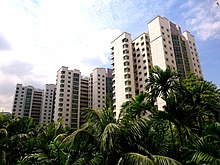
Comprising 13,810 hectares, it includes seven planning areas and is largely a residential region with 217,120 homes.
At this time the majority of urbanisation in Singapore was concentrated in the southern part of the country, where the Central Region is now located.
[7] However, this plan was soon deemed inefficient and not flexible enough to accommodate the rapid demographic and economic development in Singapore.
[6] According to the 2015 General Household Survey, the most common ethnic background in the North-East Region is Chinese, accounting for the majority of the population.
[14] Announced in 2018, the business park is expected to provide 28,000 jobs in the technology sector, specialising in cyber security, artificial intelligence (AI) and robotics, fintech, and smart living.
[15] Located within the North-Eastern Islands planning area, Pulau Ubin is a popular tourist attraction with both local and foreign visitors visiting the island as it is one of the last rural areas in Singapore, with an abundance of natural flora and fauna.
[16] Additionally, the Chek Jawa wetlands is also a popular attraction due to its array of wildlife and unique biodiversity.
Visitors to the island can participate in activities such as cycling, bird watching and nature walks.
[19] Residents living within the area have access to different educational facilities ranging from preschools to primary and secondary schools as these are located around the different towns in the North-East region.
Parks within the North-East region include:[24] The Singapore Civil Defence Force operates two fire stations in the region:[25] Ang Mo Kio Fire Station has been operational since 1984 and provides services to Ang Mo Kio and Serangoon.
[26] Along with the fire stations, there are also two fire posts in the region:[27] The public transport system in Singapore was designed to connect the North-East Region to the city centre, with Mass Rapid Transit (MRT) stations in each town centre.
[28] There is also a number of bus stops and Light Rail Transit (LRT) stations which connect towns within the region.
[31] Yio Chu Kang and Ang Mo Kio are the stations located on the North-South line in this region.
Tai Seng, Bartley, Serangoon and Lorong Chuan stations are on the Circle line in this region.
[6] Each of these housing developments are designed for self-sufficiency, with schools, hospitals, parks, sports facilities, shopping malls and other amenities easily available to residents.
New housing in Ang Mo Kio, Hougang and Serangoon is being developed, along with new transport options, parks and other amenities.
[38] In recent years, the HDB has also developed more of a focus on sustainability and incorporating ecological considerations into town planning.
[39] The National Heritage Board has designated a number of “historic sites” in Singapore, some of which are located in the North-East Region.