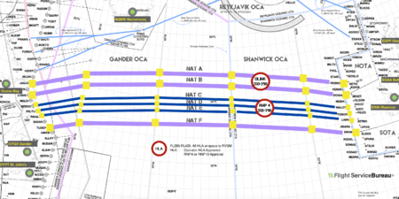
North Atlantic Tracks
These heavily travelled routes are used by aircraft flying between North America and Europe, operating between the altitudes of 29,000 and 41,000 ft (8,800 and 12,500 m) inclusive.
To make such efficiencies possible, the routes are created twice daily to take account of the shifting of the winds aloft and the principal traffic flow, eastward in North America evening and westward twelve hours later.
After World War II, increasing commercial airline traffic across the North Atlantic led to difficulties for ATC in separating aircraft effectively, and so in 1961 the first occasional use of NAT Tracks was made.
[2] Other historical dates include: The specific routing of the tracks is dictated based on a number of factors, the most important being the jetstream—aircraft going from North America to Europe experience tailwinds caused by the jetstream.
Because of the difference in ground speed caused by the jetstream, westbound flights tend to be longer in duration than their eastbound counterparts.
[citation needed] The day prior to the tracks being published, airlines that fly the North Atlantic regularly send a preferred route message (PRM) to Gander and Shanwick.
[citation needed] While the routes change daily, they maintain a series of entrance and exit waypoints which link into the airspace system of North America and Europe.
Also, pilots on the North Atlantic Tracks are required to inform air traffic control of any deviations in altitude or speed necessitated by avoiding weather, such as thunderstorms or turbulence.
These reports can be made to dispatchers via a satellite communications link (CPDLC) or via high frequency (HF) radios.
In this case, a SELCAL check only has to be performed when entering the oceanic area and with any change in radio frequency to ensure a working backup system for the event of a datalink failure.
In this manner, a single aircraft can be efficiently utilized by flying to Europe at night and to North America in the day.
The tracks are updated daily and their position may alternate on the basis of a variety of variable factors, but predominantly due to weather systems.
[citation needed] The US Federal Aviation Administration, Nav Canada, and UK National Air Traffic Services (NATS) publish a Notice to Airmen (NOTAM) daily with the routes and flight levels to be used in each direction of travel, available online.
In the three following months, 31,700 flights could fly at their optimum speeds, saving up to 400–650 kg (880–1,430 lb) of fuel per crossing.
Capacity is increased as NATS expects 16% more flights by 2025, while predicting that 10% of traffic will use the Organized Track System in the coming years, down from 38% today[when?].
An additional route, 'Track Sierra Papa' (SP), was used for seasonal British Airways flights from London Heathrow to/from Barbados.