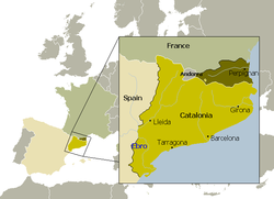
Northern Catalonia
Northern Catalonia forms a triangle between the Pyrenees to the south, the Corbières Massif to the north-west and the Mediterranean Sea to the east.
The climate is of the Mediterranean type, with hot, dry summers and winters which are relatively mild, at least on the Roussillon plain where snow is rare.
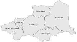
Haute-Cerdagne (Catalan: Alta Cerdanya) is geographically distinct from the rest of Northern Catalonia, lying to the south of the Pyrenean watershed in the upper valley of the Segre.
Northern Catalonia formed part of the southern counties of the Frankinsh Empire (historiographycally known as the Marca Hispanica), established by Charlemagne as a buffer territory against Al-Andalus forces.
By the end of the ninth century, these counties had gained de facto independence from the Carolingian kings and operated as princely states (whose rulers nevertheless retained the title of count).
The last Count of Rosselló, Girard II, left his title to the Crown of Aragon on his death in 1172 to prevent the territory passing to his illegitimate half-brothers.
This division satisfied neither branch of the family, and the Kingdom of Majorca was retaken militarily by the Crown of Aragon in 1344, reintegrating the counties of Roussillon and Cerdanya into the Principality of Catalonia.
The French provinces were abolished at the Revolution (Law of 1789-12-22), and Roussillon was joined with the district of Fenouillèdes (Occitan: Fenolheda) to form the département of the Pyrénées-Orientales, with Perpignan (Perpinyà) as its administrative centre.
The arrondissement of Prades (Prada) covers the whole of Haute-Cerdagne (Alta Cerdanya) and Conflent (including Capcir), as well as about a third of Fenolheda (not part of the province of Roussillon).
The arrondissement of Céret covers the whole of Vallespir but also the Côte Vermeille (Costa Vermella), which was historically under the control of the counts and veguers of Rosselló at Perpinyà (Perpignan).
Unlike the autonomous community of Catalonia, these comarques have no administrative significance, although they usually correspond to a certain historical and geographical unity.
A commonly used division is that of Joan Becat in his 1977 work Atles de Catalunya Nord, which follows closely the boundaries of the former vegueries except insofar as it promotes the former sotsvegueria of Capcir (177 km2, pop.
[5] Catalan is spoken in all regions of Northern Catalonia except for Fenolleda which speaks the related (and mutually intelligible) Occitan language.
In the 1970s, the Arrels Association and la Bressola network of private schools started to offer complete bilingual French/Catalan classes from nursery up to secondary education.