North Island surface volcanism
Much of the volcanic activity in the northern portions of the North Island of New Zealand is recent in geological terms and has taken place over the last 30 million years.
The activity has included some of the world's largest eruptions in geologically recent times and has resulted in much of the surface formations of the North Island being volcanic as shown in the map.
[9] Much further south on the west coast is the potentially active andesitic Taranaki group of stratovolcanoes that have a history of collapse events.
[10] The Tauranga Volcanic Centre on the east coast was active with andesitic and rhyolitic events between 2.95 and 1.9 million years ago.
[11] Inland from the Coromandel and Tauranga are a line of andesitic volcanoes such as Maungatautari that are located on the far side of the Hauraki Rift and have ages of about 1.8 million years.
[14] The latest activity in the Kaikohe-Bay of Islands field, around 1300 to 1800 years ago, created four scoria cones at Te Puke (near Paihia).
[18] Remnants of these two ancient volcano belts are still exposed in many places, including Whangarei Heads, the Hen and Chickens Islands, around Whangaroa Harbour, Waipoua forest, and the Waitākere Ranges.
Currently dormant, the field is likely to erupt again within the next "hundreds to thousands of years" (based on past events), a short timeframe in geologic terms.
[20] Three volcanic fields erupted between 2.7 and 0.5 million years ago, migrating northwards from Mount Pirongia to the Bombay Hills.
Unlike typical hot spots such as the one underlying Hawaii, it does not seem to have stayed still, but instead is migrating northward at a faster pace than the surrounding Indo-Australian plate.
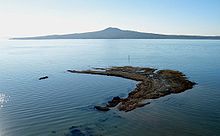
[28] Mayor Island / Tūhua is a peralkaline shield volcano with a caldera partly formed in a large eruption some 7000 years ago.
[32] This southeastward migration is the continuation of the 25 million year activity of the Northland-Mohakatino Volcanic Belt that extends mainly under the present Tasman Sea from the west of Northland down to Mount Taranaki.