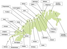
Northern Norway
Some of the largest towns in Northern Norway (from south to north) are Mo i Rana, Bodø, Narvik, Harstad, Tromsø and Alta.
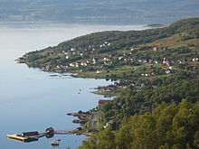
Here there is a multitude of islands and skerries on the outside of the coastal range, some flat, some with impressive shapes, like Mount Torghatten, which has a hole through it, and the Seven Sisters near Sandnessjøen.
The inland is covered with dense spruce forests and mountains near the Swedish border; some of the biggest rivers in the region are the Vefsna and the Ranelva.
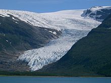
The highest mountain in Northern Norway is found here in the Okstindan range south of Mo i Rana with Oksskolten reaching 1,915 metres (6,283 ft) above sea level, and with the glacier Okstindbreen.
Notable peaks in Salten are the Børvasstindan south of Bodø, Suliskongen near Fauske (1,907 metres or 6,257 feet, highest mountain north of the Arctic Circle), the Steigartindan and the phallic Hamarøytinden.
From the mainland side it looks very barren, but behind the violet-black peaks there are also flatlands with good grazing for sheep, partially on soil made from seaweed.
The inland is covered by Finnmarksvidda, a relatively barren plateau about 300 to 400 metres (980 to 1,310 ft) high, with many lakes and rivers like Alta-Kautokeino and Tana-Deatnu.
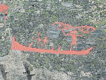
Today the rock carvings at Hjemmeluft in Alta or at Leknes in Nordland are among the remainders of the Stone Age cultures, showing reindeer swimming across the fjords.
A significant find area is between the river Tana and the fjord of Varanger, where the reindeer probably ran over the isthmus on the way between the winter and summer grazing.
[citation needed] In the Viking Age, several chieftains along the coast played a significant role in Norwegian history, usually resisting unification of Norway.
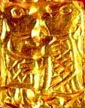
The chieftain and poet Øyvind Skaldespiller was the first to receive international acclaim, as his poems were rewarded when the Icelandic parliament organized a money collection to buy him a thick ring of gold.
In the Middle Ages, churches and fortifications were built along the coast in an effort to stake a more firm claim for the kingdom of Norway along what was then the frontier of Norwegian settlement.
The traditional view is that these were refugees escaping famine and warfare at home, although modern scholars have pointed out that many were simply looking for their own piece of land, which was getting scarce in Finland as a result of rapid population growth.
Interrupted by the British blockade of the Napoleonic wars, this introduced a period of unprecedented growth in the north as the trade monopoly had previously made cities nonviable in Northern Norway.
During the war, the area was used by the Kriegsmarine to stage U-boat attacks on Allied Arctic supply convoys resupplying the Eastern Front.
In 1979, the building of a hydro-electric dam in Alta caused huge demonstrations, giving the Sami question national attention for virtually the first time.
While there is a slight overall population growth in Northern Norway (as a result of surplus childbirths and immigration from abroad), this is significantly lower than in southern counties, although the regional centres of Bodø, Tromsø and Alta continue to grow at a relatively brisk pace.
Earlier, northern dialects had a low status in Norway, but recently they have been used extensively in song lyrics, poetry, in TV and radio.
[6] In addition to fishing, each family traditionally had a small farm with a few cows (see Pietro Querinis shipwrecked at Røst in 1432[7]), sheep or goats (goats being preferred in many places due to their superior adaptation to the rough and mountainous terrain found in much of Northern Norway) and had small grain fields (mostly barley).
Hunting has been important ever since the Stone Age, and the comparatively large areas of sparsely settled valleys, fells and mountains still hold wildlife.
[11] In later years, the large Red king crab has invaded Norwegian waters from the east and, having reached west to Hammerfest, are now served in the finest restaurants.
However, in Tromsø, sea gull eggs and beer from the local brewery is still a highly regarded dish to enjoy in the sun of late spring.
Foods with dairy as an important ingredient include waffles, pancakes and rømmegrøt (sour-cream porridge), the latter always served with sugar and cinnamon.
[19] Bioforsk, with research in terrestrial effects of climate and subarctic agriculture, has branches in four places in Northern Norway – Tromsø, Bodø, Tjøtta and Svanhovd in Sør-Varanger Municipality.
February is a transitional period when the sun rapidly returns, and March and April often feel like an explosion of light with long daylight hours and snow cover in most areas except the coastal strip of Nordland.
The largest part of North Norway are within the boreal climate (also known as subarctic), but with large variation of temperatures and precipitation from south to northeast.
A substantial area of the region, especially towards the border with Sweden and north to the Lyngen alps east of Tromsø, are mountains and highlands with alpine tundra climate above the treeline.
The warmest summer daily highs are in the inland valleys and sheltered fjords, in towns like Mosjøen, Rognan, Narvik, Bardufoss, Alta and Karasjok.
Lakselv in Porsanger Municipality at 70 degrees north latitude has a continental boreal climate with cold winters and sparse precipitation.
The Eliteserien, Norway's primary men's football league, features two Northern teams in the current 2023 season, FK Bodø/Glimt and Tromsø IL.