Northcote, Auckland
Northcote (/ˈnɔːrθkoʊt/ NORTH-koat[3] or /ˈnɔːrθkət/ NORTH-kət) (Māori: Te Onewa)[4] is a suburb of Auckland in northern New Zealand.
Early industries included the brickworks, sulfur works and orchards, and by the 1880s Northcote beaches had become local attractions.
[6] The North Shore is primarily uplifted Waitemata Group sandstone, that was deposited on the sea floor during the Early Miocene, between 22 and 16 million years ago.
[11] There are two volcanic craters found on the eastern coastline of the suburb: Tank Farm, also known as Tuff Crater or Te Kōpua ō Matakamokamo,[12] joined to the south by Onepoto (also known as Te Kōpua ō Matakerepo).
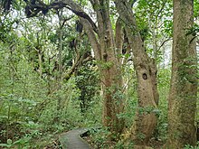
[15] Prior to human settlement, the inland North Shore was a mixed podocarp-broadleaf forest dominated by kauri.
[11] Smiths Bush in the Onewa Domain is a remnant native forest, dominated by kahikatea and taraire trees.
[22] Onepoto Stream flows east through the suburb from Birkenhead, entering Shoal Bay south of Onewa Road.
[34][35] The Tainui migratory canoe visited Northcote, stopping at Ngā Huru-a-Taiki, a sacred tree on the cliffs south-east of Tank Farm.
[36][28][27] The North Shore was settled by Tāmaki Māori, including people descended from the Tainui migratory canoe and ancestors of figures such as Taikehu and Peretū,[37] and many of the early Tāmaki Māori people of the North Shore identified as Ngā Oho.
[38] The Shoal Bay area was used to harvest shellfish, and the volcanic soil at Northcote allowed for kūmara cultivation.
[39] The warrior Maki migrated from the Kāwhia Harbour to his ancestral home in the Auckland Region, likely sometime in the 17th century.
His younger son Maraeariki settled the North Shore and Hibiscus Coast, who based himself at the head of the Ōrewa River.
[43][44] Northcote is part of the setting of Te Riri a Mataaho ("The Wrath of Mataaho"), a Ngāi Tai ki Tāmaki traditional story (pūrākau) that describes the creation of the two volcanic craters of Northcote, Te Kōpua ō Matakamokamo and Te Kōpua ō Matakerepo, collectively called Ngā Kōpua Rua ("The Two Deep Pools").
[45][14] Two tupua (children of the Fire God Mataaho), Matakamokamo and his wife Matakerepo, lived on Te Rua Maunga, a mountain located at Lake Pupuke.
[46][14] The couple argued over some flax clothing that Matakerepo had made for her husband, and the argument became so heated that the fire outside their dwelling died out.
He turned the couple into stone and caused them to link beneath the earth, forming the two volcanic craters.
[44] The site has traditional importance to Ngāi Tai ki Tāmaki, Te Kawerau ā Maki and Ngāti Paoa,[44][38][47] and was located on the opposite shore to Point Erin, where a pā called Okā or Te Koraenga was located.
[44] It was prized for its strategic location and view over the Waitematā Harbour, and protected fisheries and kūmara gardens of the nearby volcanic soil.
[56] In the next few years, other settlers including James Kelly, William Nicholson, Patrick Heath moved to Northcote.
[57] The greater Northcote area was purchased by the New Zealand Company in 1844, intending to develop a colonial settlement.
[51] From 1848, a soap and candle factory was established on Sulphur Beach,[56] and other early industries included timber milling and kauri gum digging.
[66] Northcote Point grew to become a commuter suburb for people working in Auckland, due to the ferry service.
[77][78] A 75 foot (23 m) flagstaff was erected at Stoke Point, a memorial tōtara tree was planted at the site, named Tainui by Māori local to the North Shore,[79][80] and the Stokes Point headland gained the name Tōtara-tahi ("The Single Tōtara Tree").
[10] In 1903, the Northcote Athenaeum Society was established, which organised pleasurable literary and musical evenings for residents, including recitals poetry readings and plays.
[83][10] A new concrete road and bus barns were constructed in 1927, joined in the same year by a cinema called the Onewa Picture Drome.
[10] By the 1920s, the gas works at Little Shoal Bay, first established in 1902, had become the biggest single employer in the Northcote Borough.
[11] The Northcote War Memorial Library, designed by Thorpe, Cutter, Pickmere and Douglas, was formally opened on 10 March 1956.
[87] Construction of the harbour bridge and the Auckland Northern Motorway led to major changes in the environment.
[119] The Northcote area war memorial stands at the front of the school, on the corner of Lake and Onewa Roads.
This proposed station was cancelled in December 2000, after lobbying by residents, who were concerned about increased traffic and public transport in the area.