Inner Banks
The Inner Banks is a neologism made up by developers and tourism promoters to describe the inland coastal region of eastern North Carolina.
Without historical precedent, the term "Inner Banks" is an early 21st-century construct that is part of an attempt to rebrand the mostly agrarian Coastal Plains east of I-95 as a more attractive region for visitors and retirees.
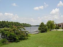
The present term suggests relation to the historical area known as the Outer Banks, a string of barrier islands off the coast of North Carolina that have long been a popular tourist attraction.
The demand for waterfront property in eastern North Carolina as a site for second homes for the relatively wealthy has resulted in a tremendous disparity of prices in such locales.
[citation needed] The developers and tourism promoters have broadly defined the Inner Banks as an area on the East Coast of North Carolina that is 22,227 square miles (57,568 km2).
Traditionally dependent on agriculture and the textile industry, eastern North Carolina has worked to redefine the region's strengths to transition into the new global economy.
Major planters imported thousands of enslaved Africans for their work force through 1808, when the Atlantic trade was prohibited by Congress.
The area continued to rely on agriculture for its main economic base, which suffered a decline through the end of the 19th century.