O-Bahn Busway
The O-Bahn system was conceived by Daimler-Benz to enable buses to avoid traffic congestion by sharing tram tunnels in the German city of Essen.
[1] Adelaide's O-Bahn was introduced in 1986 to service the city's rapidly expanding north-eastern suburbs, replacing an earlier plan for a tramway extension.
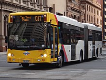
The track is 12 kilometres (7.5 mi) long and includes three interchanges at Klemzig, Paradise and Tea Tree Plaza.
The O-Bahn track is made of concrete; it is elevated from the ground because of the poor quality of alluvial soils along the River Torrens, which frequently move due to their high level of plasticity.
5,600 pylons were drilled in place to support 5,600 sleepers and 4,200 prefabricated L-shaped track pieces, sited at 12-metre (39 ft) intervals.
[5][6] The O-Bahn's concrete tracks were narrower and lighter than those of the initially proposed light rail development, and put less stress on the land.
The bus lane continues north to the River Torrens and into the original entrance of the O-Bahn on Hackney Road, opposite the East Parklands, where it enters a 60-metre (200 ft) tunnel at a speed limited to 40 km/h (25 mph), due to the tight initial corner, ensuring that the rear tyres (especially trailer tyres of articulated buses) do not 'scrub' against the track.
[8][9] The O-Bahn is officially considered a road, due to a court ruling in the early years of the system's operation.
[10] These were modified for O-Bahn use by Mitsubishi Motors' Clovelly Park plant before being bodied by Pressed Metal Corporation South Australia.
In the early stages of design it was intended that all buses would have towing ability; however, this was soundly rejected by the drivers' union and 'Dumbo' was purchased.
The terminus before the completion of Stage 2, it is now served by buses from suburban streets, and has a total of 875 car parking spaces in two areas.
The terrain becomes steeper as the busway proceeds up along the outflow creek and past the northwestern side of the Hope Valley Reservoir.
The resulting 300-page study, "Report on the Metropolitan Area of Adelaide 1962", laid out a 30-year development plan, including a proposed 98 kilometres (61 mi) of improved roadways.
MATS drew massive public opposition, as it called for the acquisition of thousands of properties and would effectively supplant a number of suburbs that were to become the sites of interchanges.
Nonetheless, in early 1969 Premier Steele Hall approved implementation of the plan in a modified format, and the government began to purchase property along the proposed corridors.
Hall was voted out of office in 1970, and the new government under Premier Don Dunstan passed a 10-year moratorium on freeway development, effectively shelving MATS.
[35] A corridor of land along the River Torrens from Adelaide to Modbury, originally purchased for the Modbury Freeway proposed under the MATS plan, was the subject of a new proposal in 1973 when the State Director-General of Transport suggested building a heavy rail line that would connect the suburb to the Adelaide railway system.
The new route was to continue along King William Street beyond what was then the terminus in Victoria Square and weave through the Adelaide Park Lands to the Modbury corridor.
[8][36] The light rail system would connect with feeder buses at stations along the length of the corridor to transfer passengers to suburban routes.
Residents in inner-city suburbs such as St Peters were concerned about the noise of the light rail vehicles, and protested against any disruption of the Torrens Gorge in the Modbury corridor.
Test drilling commenced for the tunnel, but the entire light rail project was halted in 1980 after Premier David Tonkin appointed Michael Wilson, an opponent of the plan, as Transport Minister.
[8][36] In search of a replacement for the light rail project, the new Government sent experts to examine an innovative guided bus system being developed in West Germany by Daimler-Benz.
In addition, its unique feature of a non-transfer service direct from suburban streets to the city centre made it more attractive.
Population increase in the area is negligible, although sprawl continues from Tea Tree Plaza Interchange for another eight kilometres to the Adelaide Hills.
Sage Automation provided expertise in the mechanical and electrical aspects of the tunnel including ventilation and safety systems.
[58][59] The O-Bahn has caused a clustering of commercial and community development near the Tea Tree Plaza Interchange, as service-providing organisations and businesses have sought to exploit the area's easy accessibility to public transport and the city centre.
According to Robert Cervero, the O-Bahn has "accelerated the conversion of Tea Tree Gully from a somewhat sterile new town designed around a regional shopping mall to an emerging urban village featuring a wide range of land uses".
[60] The large Modbury Hospital is adjacent to the interchange, and the Torrens Valley campus of TAFE was built directly to the east of the busway after it opened.
[62] Torrens Linear Park rejuvenated the river, which had deteriorated to the extent of being a de facto "urban drain, littered with rubbish and inaccessible to the public".
[39] The track itself is situated in a valley due to it being near a riverbed and the elevation was further lowered by digging further depressions in order to reduce the noise impact on adjacent dwellings.