Oak Ridges Moraine
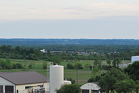
One of the most significant landforms in southern Ontario, the moraine gets its name from the rolling hills and river valleys extending 160 km (99 mi) east from the Niagara Escarpment to Rice Lake, formed 12,000 years ago by advancing and retreating glaciers (see geological origins, below) during the last glaciation period.
Rivers and lakes scatter the landscape and are important for creating habitat for the rich diversity of species of animals, trees and shrubbery (see ecology).
It is bounded to the west by the Niagara Escarpment, a cuesta which was critical to the formation of the moraine, and to the east by the Trent River and Rice Lake.
Near the Rice Lake wedge and Peterborough drumlin field are a couple of low-lying terrain plains and small hills on bedrock basement.
Sedimentary glaciofluvial areas form the core of the Oak Ridges Moraine, though restricted to subglacial cavity fills of confined subaqueous fans.
Overlaying this core is a glaciolacustrine sedimentary layer that is younger and topographically lower, principally in the delta and basin areas of the moraine.
Research suggests that sedimentation occurred in a west to east sequence along the four main sedimentary wedges: Albion, Uxbridge, Pontytool and Rice Lake.
The wedges may have formed in a relatively short period of time, perhaps no more than a few hundred years, as indicated by the annual deposition cycles in glacial lakes (known as varves) within the moraine sediments.
In the area of the Oak Ridges Moraine, glacially derived sediments, mainly of Pleistocene age, may overlie a regional unconformity and lower Newmarket till, up to 200 metres thick in some places.
There are lower deposits of sand, silt and clay, which rest directly above the regional time unconformity up to 100 metres (330 ft) thick in some areas.
Next comes the Newmarket Till of stony, silty sand and sandy-silt diamicton ranging from 5 to 50 metres (16 to 164 ft) thick and is thought to extend southward under Lake Ontario.
Some channel fills are 10 to 25 metres of gravels or 10-to-75-metre (33 to 246 ft) sands that decrease in grain size during later deposition following a period of slowing meltwater runoff.
[4] A large time gap is important in this context to correlate where and when this event occurred with respect to both local and surrounding geology of the lithostratigraphic and geographical record.
Cause of this stratigraphic gap may originate from a couple large scale meltwater events, the older Algonquin and younger Ontarian erosional floods from melting glaciers of the Late Wisconsinan glaciation.
[6][11] This broad range of thickness is representative of the unequal effects of regional erosion, uplift, sedimentary deposition and continental processes (tectonics, building and destroying of continents).
Varied landforms on the moraine, such as woodlands, wetlands, watercourses, kettle lakes and bogs, have provided an environment suitable for significant flora and fauna communities to develop and thrive.
[17] A study by Cook et al. (1985) found an increase in mean annual runoff, instantaneous discharge, and hydrograph peak flow as a result of urbanization: "...changes in land use coincided with changes in volumetric and time distribution aspects of hydrologic response".
The oldest artifact found in what is now Richmond Hill, Ontario, from these people, was a stone scraper about 40 mm long, at the Mortson Site, near Leslie Street and 19th Avenue.
[19] Part of the reason for its entry into political discourse, was due to the formation, in 1989, of the Save the Oak Ridges Moraine (STORM) Coalition.
On July 20, 1999, Minister of Municipal Affairs and Housing Steve Gilchrist announced, on "Rouge Park Day", that he would be implementing a ban on all development on the Oak Ridges Moraine.
A media campaign by environmental groups built on the public opposition of the developments, and the issue was transferred to the Ontario Municipal Board (OMB) in 2000.
Given that the land-subdivision process is lengthy and that Markham, Vaughan, Richmond Hill, Whitchurch-Stouffville and King Township are experiencing a shortage in servicing capacity, what often appears as "new" development in Markham, Vaughan, Richmond Hill, Whitchurch-Stouffville and King Township on the moraine is in the majority of cases development which has had approval for many years.
The estimated current population on the moraine land itself is roughly 200,000 but this number continues to grow at a frantic pace, with large urban developments occurring in Stouffville, Vaughan, Richmond Hill, and Aurora.
Use of the moraine is currently under dispute; environmental groups such as the Sierra Club maintain the area's delicate ecosystems are threatened by development pressures.
Attractive forests and hilly relief typical of the moraine are a magnet for developers looking for building opportunities in the densely populated Greater Toronto Area.
The Nature Conservancy of Canada is also active and are raising funds to protect a 5.4 km2 (1,300 acres) property called Happy Valley Forest.