Ocean Observatories Initiative
This networked infrastructure measures physical, chemical, geological, and biological variables from the seafloor to the sea surface and overlying atmosphere, providing an integrated data collection system on coastal, regional and global scales.
Locations of OOI's global arrays were selected by a team of roughly 300 scientists[14] to target regions that were under-sampled and subject to extreme conditions (e.g., high winds and sea states) that were challenging for continuous or even frequent ship-based measurements.
The originally planned global study sites include instrumented moorings and gliders in four locations: Argentine Basin, Irminger Sea, Southern Ocean, and Station Papa.
The first year of funding under the Cooperative Agreement supported a range of construction efforts performed by the Marine Implementing Organizations (Woods Hole Oceanographic Institution, University of Washington, and Oregon State University), including production, engineering, and prototyping of key coastal and open-ocean components (moorings, buoys, sensors), award of the primary seafloor cable contract, completion of a shore station for power and data, and software development for sensor interfaces to the network.
In October 2018, the Program Management office of the OOI shifted from the Consortium for Ocean Leadership to the Woods Hole Oceanographic Institution.
[19] The sites and platforms of the OOI components target the following key scientific processes: Quantifying the air-sea exchange of energy and mass, especially during high winds (greater than 20 meters-per-second), is critical to providing estimates of energy and gas exchange between the surface and deep ocean and improving the predictive capability of storm forecasting and climate change models.
Lithospheric movements and interactions at plate boundaries at or beneath the seafloor are responsible for short-term events such as earthquakes, tsunamis and volcanic eruptions.
In 2024, the Coastal Pioneer Array was relocated to the southern Mid-Atlantic Bight, between Cape Hatteras and Norfolk Canyon off the coast of North Carolina.
[24] Coastal Pioneer Array data enable scientists to examine how exchange processes structure physical, chemical and biological properties over the continental shelf and slope.
[25] Continuous rapid sampling at intervals of hours to days over multiple spatial scales (meters to hundreds of kilometers) provides insight into oceanographic processes that occur through more than one seasonal or annual cycle.
[25] The Coastal Endurance Array, located on the continental shelf and slope off Oregon and Washington, provides a long-term network of moorings, benthic nodes, cabled and uncabled sensors and gliders.
[23][28] Some Endurance Array Oregon Line infrastructure connects to the RSN cabled network to provide enhanced power and communications for observing water column and seafloor processes.
[27] Locations of the global arrays were selected by a team of scientists (~300 people)[29] based on regions that are under-sampled and subject to extreme conditions (e.g., high winds and sea states) that are challenging for continuous or even frequent ship-based measurements.
The planned global study sites included instrumented moorings and gliders in four locations: Argentine Basin;[30] Irminger Sea;[31] Southern Ocean;[32] and Station Papa.
The global arrays include moorings composed of fixed and moving sensors that measure air-sea fluxes of heat, moisture, and momentum—as well as physical, biological, and chemical properties of the water column.
Continuous measurements of physical, biological, and chemical properties will help monitor mesoscale and large-scale patterns such as the Pacific Decadal Oscillation.
Its observations allow for the in-depth study of volcanic activity, methane seeps, hydrothermal vents, and submarine earthquakes, as well as biological, chemical, and physical processes in the overlying water column.
The cables provide two-way real-time communication between the seafloor and water column instrumentation and the shore station in Pacific City, Oregon.
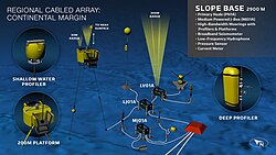
The slope base site is located about 125 km west of Newport, Oregon and sits at a depth of 2900 m. It hosts both seafloor and instrumented profiling moorings and allows investigation of the variability and interactions of deep ocean waters, the California Current, and upwelling.
The RCA complements the NEPTUNE cabled observatory that Ocean Networks Canada operates on the northern Juan de Fuca plate.
Geophysical observations at the Slope Base site detect seismic and tsunami events associated with earthquakes along the Cascadia subduction zone and far field.
New overview and quantification sonars funded by Germany through the Bremen University, for the first time, image all methane plumes emanating from Southern Hydrate Ridge.
Fiber-optic cables provide power and two-way communication to Junction Boxes, which house sensors and geophysical instruments such as seismometers and hydrophones.
Junction Boxes paired with Cabled Deep and Shallow Profiler Moorings at the slope base site take observations throughout the water column from seafloor to ocean surface.
[38] Seafloor infrastructure includes a broadband seismometer and low frequency hydrophone to monitor local and far-field seismic events.
Broadband hydrophones on the moorings from Axial to the Oregon Shelf site delineate mammal vocalizations, and sounds made by human activities.
These instruments span broad science investigations into crustal deformation at the volcano with follow-on studies focused on Cascadia Subduction Zone earthquakes.
Data collection aims to find connections between ocean dynamics, ecosystems, and climate at a range of scales, from basin to regional level.
Seafloor infrastructure, such as a broadband seismometer and low-frequency hydrophone, allows the RCA to monitor local and far-field seismic events.
[40] The OOI Cyberinfrastructure (CI) manages and integrates data from more than 800 instruments deployed across the five ongoing ocean arrays, linking the marine infrastructure to the global community of users.