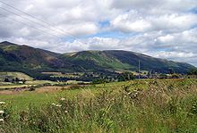
Ochil Hills
The only major roads crossing the hills pass through Glen Devon/Glen Eagles and Glenfarg, the latter now largely replaced except for local traffic by the M90 Edinburgh-Perth motorway cutting through the eastern foothills.
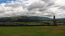
[4] Historically, the hills, combined with the town's site at the lowest bridging-point on the River Forth, led to Stirling's importance as a main gateway to the Highlands.
In the early Industrial Revolution, several mill towns such as Tillicoultry, Alva and Menstrie (the Hillfoots Villages) grew up in the shadow of the Ochils to tap the water power.
[6] The Ochil Volcanic Formation, a sub-unit of the Arbuthnott-Garvock Group, consists of basaltic andesite and trachyandesite lavas and related rock types erupted during the Early Devonian epoch.
Castle Craig, a ruined ancient fort above the village of Mill Glen destroyed by industrial quarrying, was mentioned by local historian William Gibson in 1883 as being "a round Pictish fortress, the traces of which can still be distinctly seen.
Another item of folklore existing in the Ochil Hills is Katie Thirsty's Well, a sacred well shrouded in mythology (OS Grid Reference – NS 81787 97653).
Following approval in early 2007, the construction of a wind farm consisting of thirteen 102 m (335 ft) turbines on Burnfoot Hill, which lies north of Tillicoultry and Ben Cleuch and to the south of the Upper Glendevon Reservoir has been completed.
[11] The windfarm is owned and run by EDF Renewables, who support the work of the Ochils Mountain Rescue Team through the Burnfoot Hill Community Fund with an annual donation of £5,000 guaranteed till 2039.