Ohio and Erie Canal
Most of the surviving portions in the Akron-Cleveland area are managed by the National Park Service or Ohio Department of Natural Resources.
Without easy access to distant markets, agriculture served only local needs and large-scale manufacturing was nearly non-existent.
On January 15, 1812, the Ohio General Assembly passed a resolution expressing its opinion that the connection of the Great Lakes with the Hudson River was a project of "national concern".
Finally, in January 1822, the Ohio Legislature passed acts to fund the canal system (and the state's public education obligations).
On January 31, 1822, the Ohio General Assembly passed a resolution to employ an engineer and appoint commissioners to survey and design the canal system as soon as possible.
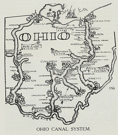
Since most of Ohio's population lived along a line from Cleveland to Cincinnati, the main trunk of the canal needed to serve these areas.
By damming the rivers, long stretches of slackwater could be created which, with the addition of towpaths, could serve as portions of the canal.
[citation needed] Contracts were let for the following tasks: Grubbing and clearing, Mucking and ditching, Embankment and excavation, Locks and culverts, Puddling, and Protection.
While the average speed of 3 mph (5 km/h) may seem slow, canal boats could carry 10 tons of goods and were much more efficient than wagons over rutted trails.
In addition, there were five feeder canals that added 24.8 miles (39.9 km) and 6 additional locks to the system consisting of: The canal's lock numbering system was oriented from the Lower Basin, near the southwest corner of the current Exchange and Main streets in Akron.
In many cases, canals were filled in for "health reasons", with a newly laid railroad track on their right of way.
[11] As a teenager during 1847, James Garfield worked as a "hoggee", driving mules to pull barges along the canal.
[1][3] It is a four-mile (6 km) section within the village of Valley View comprising three locks, the Tinkers Creek Aqueduct, and two other structures.
Another watered section extends from the Station Road Bridge in Brecksville northwards into Valley View and Independence, all Cleveland suburbs.
The Metroparks manage the adjacent real estate and the surrounding Ohio & Erie Canal Reservation.
This section runs from downtown Akron, through Summit Lake south to Barberton, a distance of about 12 miles (19 km).
Included in this section is the feeder canal from the Tuscarawas River and the hydraulics (flood control) at the Portage Lakes.
Most of the siltation and erosion problems experienced presently are the result of stormwater inappropriately piped into the canals over the years.
Another section still watered, approximately one mile in length, runs along Canal Road in Pickaway County southwest of Circleville.
A map showing the disposition of the canal lands[14] is available on-line from the Ohio Department of Natural Resources.