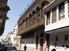
Old city of Damascus
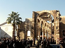
In 1979, the historical center of the city, surrounded by walls of Roman era, was declared a World Heritage Site by UNESCO.
With an approximate area of 86.12 hectares (212.8 acres; 0.86 km2), the ancient city was enclosed within a historic wall of 4.5 km (2.8 mi) in circuit that was mainly built by the Romans, then fortified by the Ayyubids and Mamluks.
[2] The first mentioning of Damascus was as "Ta-ms-qu" in the second millennium BC, it was situated in an Amorite region in the middle of a conflict zone between the Hittites and Egyptians.
The city was tributary to these powers until the emergence of the Sea Peoples in 1200 BC whose raids helped in weakening the arch rivals.
Consequently, the Semitic Arameans managed to establish the independent state of Aram-Damascus (11th century – 733 BC), naming the main city as ‘Dimashqu’ or ‘Darmeseq’.
Since the city has been built up with every passing occupation, it has become almost impossible to excavate all the ruins of Damascus that lie up to 2.4 m (8 ft) below the modern level.
[14] Due to the rapid decline of the population of Old Damascus (between 1995 and 2009 about 30,000 people moved out of the old city for more modern accommodation),[15] a growing number of buildings are being abandoned or are falling into disrepair.
In March 2007, the local government announced that it would be demolishing Old City buildings along a 1,400 m (4,600 ft) stretch of rampart walls as part of a redevelopment scheme.