Old Mines, Missouri
[3] This culturally distinct population has sometimes been referred to as "paw-paw French"[4][5] and lives in an amorphous area in Washington, Jefferson, and St. Francois counties roughly 15 miles (24 km) either side of a line from Potosi to De Soto.
[6] Found first in surface deposits over a wide area, and now mined deep underground, the ore was known to the native Indians of the region from whom it became known to early French explorers.
Father Jacques Gravier noted in his journal in October 1700, the presence of rich lead ore twelve or thirteen leagues from the mouth of the "River Miaramigoua" (Meramec), that is 36 to 39 miles (58 to 63 km).
Renault found and successfully worked large quantities of lead on the "Merameg" in what is now the Old Mines region.
[12] Austin's success at Mine à Breton sparked increased attention from interests in Ste.
When news of the retrocession of Louisiana from Spain to France reached the area, both inhabitants and the absentee interests became more concerned about land ownership.
Until around the beginning of the 19th century there was little competition for land, and the French had maintained a casual attitude concerning formalities of ownership.
[17] Most of the French ignored the assignment of ownership and continued to live where they had, mostly in the village of Old Mines near the south of the concession, and at Racola near the center.
[18] After the Americans acquired control of the area there was a scramble to certify land claims with the new administration, and much of the activity was fraudulent.
[19] The Old Mines concession persists today as one of the many colonial-era grants recognized by and superimposed on the regular township grid of the American Public Land Survey System, and the pattern of long, narrow plots is visible in aerial photography as found at 38°02′24″N 90°45′32″W / 38.0401°N 90.759°W / 38.0401; -90.759 Most of the lots in the Old Mines concession were bought by outsiders, but they were speculators who had no permanent interest in the area.
[22] Men would dig tiff a couple days each week to support their families, with additional sustenance coming from home gardens.
[4] Eventually the wagon road that Moses Austin had built to haul ore to Herculaneum, which passed through Old Mines, was replaced by a railroad which did not, and the area's isolation became deeper.
[24] The French resented the economic dominance of the Americans to whom they had to sell their ore, and unlike the situation in Ste.
The name has been described as a "fun-loving insult" referring to a French creole "so poor that he lived on pawpaw in the summer and possum in the winter.
Miller also reported incursions of English into French sentences ("Anyhow, je ne sais pas.
"), and English words adapted to modern items for which the locals' French forebears had left no names ("un can de maiz").
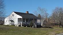
[33] Three years older than St. Louis' Old Cathedral, still in use and a center of community life,[34] St. Joachim is one of the oldest standing churches in Missouri.
A variety of forces converged in the first part of the 20th century to break down the community's isolation and accelerate assimilation into American culture.
[3] In the 1930s the prices offered for tiff tumbled, ending more than 200 years of subsistence based on small-scale mining.
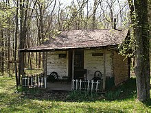
The Old Mines Area Historical Society – La Société Historique de la Région de Vieille Mine – works to preserve and promote the French culture and history of the region and has assembled an outdoor museum of historic buildings in Fertile, Missouri.
Dr. Rosemary Hyde Thomas, a scholar of the region, has worked to reinforce the culture, as has the Rural Parish Workers of Christ the King in Fertile.
[36] Historian and musician Dennis Stroughmatt, who learned to speak French there, promotes the language and folk music of Old Mines.