Oodnadatta
Town facilities include a hotel, caravan park, post office, general stores, police station, hospital, fuel and minor mechanical repairs.
From the 1880s to the 1930s, Oodnadatta was a base for camel drivers and their animals, which provided cartage when the railway was under construction and along outback tracks before roads were established.
[9] After the railway line was lifted, Oodnadatta's role changed from that of a government service centre and supply depot for surrounding pastoral properties to a residential freehold town for Aboriginal families who, moving from cattle work, bought empty houses as their railway employee occupants left.
[13] The course chosen for the Central Australia Railway likewise followed the route because a water supply was essential for steam locomotives.
From 1891, Oodnadatta was an important station on the railway until the line closed in 1981, to be replaced in 2004 by the Adelaide–Darwin rail corridor about 160 km (100 mi) to the west.
[21][22] In 1889, Angle Pole was also proposed as the south-eastern terminus of a land grant railway from Roebuck Bay in Western Australia.
This railway was proposed by a London syndicate and would have been about 1000 miles (1600 km) long, with the wider 1,600 mm (5 ft 3 in) gauge.
The railway was built with narrow gauge (1,067 mm (3 ft 6 in)) tracks, and train traffic was frequently disrupted by washouts and other damage to the trackbed, leading to a slow and unreliable service.
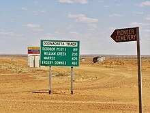
[citation needed] Tourist traffic along the Oodnadatta Track and the mining industry keep the village alive.
The town's drinking water supply was previously untreated groundwater from the Great Artesian Basin, which the state government warned residents to avoid as early as the 1980s due to the risk of the rare life-threatening brain infection primary amoebic meningoencephalitis.
[29] The 1290 metres (1410 yards) air strip adjacent to the town, originally built during World War II,[30] has a sealed surface.