Opava (river)
It flows through the Moravian-Silesian Region in the Czech Republic and along the Opole Voivodeship in Poland.
[4] In a broader point of view, the Opava (as Černá Opava) originates in the territory of Zlaté Hory in the Hrubý Jeseník mountain range, on the slope of the Orlík mountain at an elevation of 1,062 m (3,484 ft), and flows to Ostrava, where it enters the Oder River at an elevation of 207 m (679 ft).
It is 129.3 km (80.3 mi) long, making it the 15th longest river in the country.
The river flows through the municipal territories of Vrbno pod Pradědem, Karlovice, Široká Niva, Nové Heřminovy, Zátor, Brantice, Krnov, Úvalno, Brumovice, Holasovice, Opava, Velké Hoštice, Kravaře, Štítina, Mokré Lazce, Háj ve Slezsku, Dolní Benešov, Kozmice, Dobroslavice, Děhylov, Hlučín and Ostrava.
The largest of them is the Slezská Harta Reservoir with an area of 840 ha (2,100 acres).
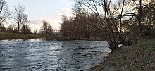
The most popular part is the lower section of the river from Kravaře to Ostrava with a length of about 30 km (19 mi), which is passable all year round and is suitable for less experienced paddlers.