Orange River
With a total length of 2,432 km (1,511 mi), the Orange River Basin extends from Lesotho into South Africa and Namibia to the north.
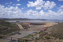
The Orange River plays an important role in the South African economy by providing water for irrigation and hydroelectric power.
[6] The Orange rises in the Drakensberg mountains along the border between South Africa and Lesotho, about 193 km (120 mi) west of the Indian Ocean and at an altitude of over 3,000 m (9,800 ft).
The Orange River then runs westward through South Africa, forming the south-western boundary of the Free State province.
At the western point of the Free State, southwest of Kimberley, the Orange meets with its main tributary, the Vaal River, which forms much of the northern border of the province.
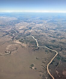
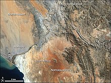
From here, the river flows further westward through the arid wilderness of the southern Kalahari region and Namaqualand in the Northern Cape province to meet with Namibia at 20°E longitude.
From here, it flows westward for 550 km (340 mi),[9] forming the international border between the province and Namibia's ǁKaras Region.
In the last 800 km (500 mi) of its course, the Orange receives many intermittent streams (such as the Fish River), and several large wadis lead into it.
In this section, the Namib Desert terminates on the north bank of the river, so under normal circumstances, the volume of water added by these tributaries is negligible.
The Augrabies Falls are located on this section of the Orange, where the river descends 122 m (400 ft) in a course of 26 km (16 mi).
Some 33 km (21 mi) from its mouth, it is obstructed by rapids and sand bars and is generally not navigable for long stretches.
[15] Other sites said to be lairs of the creature include the pool beneath the King George Cataract at Aughrabies Falls, which is also said to be a source of diamonds,[15] and a large rock in the middle of the river itself.
Today, several commercial diamond mines operate along the final stretch of the Orange River and around its mouth.
Because of the lack of dangerous animals and high water levels during summer, the river is used for recreational canoeing and rafting.
From here, the water is supplied in two directions, westward along the Orange River (via hydroelectric power generators) to the Vanderkloof Dam and southward through the Orange-Fish Tunnel to the Eastern Cape.
During the temperate months of March and April, given good rains and the sluices of the dams being open, a canoeist (or rafter) can easily travel 30 kilometres (19 mi) per day.
The two non-native species recorded in the surveys were Cyprinus carpio and Oreochromis mossambicus, the latter of which had increased rapidly in abundance since the early 1980s.