Oregon Caves National Monument and Preserve
The protected area, managed by the National Park Service (NPS), is in southwestern Josephine County, near the Oregon–California border.
Over the next two decades, private investors failed in efforts to run successful tourist ventures at the publicly owned site.
The growing usage of the automobile, construction of paved highways, and promotion of tourism by boosters from Grants Pass led to large increases in cave visitation during the late 1920s and thereafter.
At the same time, the segment of the creek that flows through the cave was renamed for the mythological Styx and added to the National Wild and Scenic Rivers System.
The parent rock was originally limestone that metamorphosed to marble during the geologic processes that created the Klamath Mountains, including the Siskiyous.
The monument consists of 484 acres (196 ha)[5] in the Rogue River – Siskiyou National Forest, about 6 miles (10 km) north of the Oregon–California border in Josephine County.
[13] Even so, no evidence has been found to suggest that any of the native peoples, such as the Takelma who lived along the Rogue and Applegate rivers in the 19th century, used the cave.
[3] Largely bypassed by the early non-native explorers, fur traders, and settlers because of its remote location, the region attracted newcomers in quantity when prospectors found gold near Jacksonville in the Rogue River valley in 1851.
[16] Elijah Jones Davidson, who discovered the cave in 1874, had emigrated from Illinois to Oregon with his parents, who eventually settled along Williams Creek in Josephine County.
On the second visit, there was "an orgy of destruction"[20] in which passages were widened, formations broken or deliberately removed, and directional arrows added to the cave walls.
Three years later, Congress passed the Antiquities Act, which allowed the President to designate protected areas called National Monuments on public lands.
In 1909, President William Howard Taft established Oregon Caves National Monument, to be managed by the USFS.
[24] Campaigns to attract car-driving tourists included those of the Cavemen, a booster group from Grants Pass that dressed in animal skins, posed along tour routes, and staged annual events to promote the monument.
[24] The visitors' need for overnight lodging led to creation of public and private campsites and rustic cabins along highways near Cave Junction and the monument.
[3] The Chalet, a building with a kitchen, dining room, gift shop, ticket sales area, and a dormitory for women on the Oregon Caves Company staff, was completed later that year.
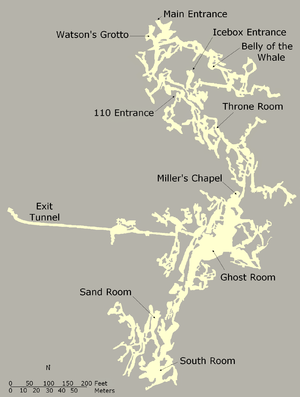
[27] It provided funds for electric lights, a power plant, a system of pipes and hoses to wash mud from the cave,[n 2] and an artificial exit tunnel to eliminate the crowding that occurred when two groups on round-trip tours had to pass one another.
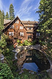
[29] Management of the monument was transferred from the Forest Service to the NPS in 1933, and a six-story hotel, the Oregon Caves Chateau, was completed at the site in 1934.
[3] Gust Lium, a builder from Grants Pass, oversaw construction of the Chateau and some of the park's other buildings, which he designed in a rustic style.
[30] Mason Manufacturing of Los Angeles produced the Chateau's furniture in a style called Monterey, valued in the 21st century at up to $5,000 for a single chair.
[31] During the 1930s and early 1940s, the Civilian Conservation Corps (CCC) installed water and telephone lines, improved trails, and worked on landscaping at the park.
[35] Although hunting is allowed in the preserve but not in the monument, the new arrangement seeks to end cattle grazing in the Cave Creek – River Styx watershed.
[36][n 3] The parent rock in which the cave developed was formed about 190 million years ago as limestone that was part of a tectonic plate beneath the Pacific Ocean.
[5] Species lists for the park include about 50 mammals, 86 birds, 11 reptiles and amphibians, 8 bats, more than 200 arthropods, 8 snails and slugs, 75 butterflies, more than 55 moths, and 8 aquatic macroinvertebrates.
[5] Outside the cave, the black-tailed deer, Steller's jay, the common raven, and Townsend's chipmunk are among animals often seen in the park.
[5] Animal species in the park with special conservation status are the northern spotted owl, California mountain kingsnake, tailed frog, Del Norte salamander, northern goshawk, olive-sided flycatcher, little willow flycatcher, Siskiyou gazelle beetle, and Pacific fisher.
Cave tours are usually offered from mid-April to early November, but the schedule depends in spring and fall on weather conditions.
[52] The basic ranger-guided "discovery cave tour", 90 minutes long, requires negotiating more than 500 steep and uneven stairs and passageways with as little as 45 inches (110 cm) between floor and ceiling.
[52] Children under 42 inches (110 cm) tall or who are unable to climb a set of test stairs on their own are not allowed on the full cave tour.
[62] No Name Trail, 1.3 miles (2.1 km) long, begins behind the visitor center, follows Cave Creek, crosses it, and then climbs steeply to the west side of the monument.
[64] Old Growth Trail, 0.8 miles (1.3 km) long, links the Chateau and visitor center to the main parking lot.