Oslofjord Tunnel
It acts as a link connecting eastern and western Akershus county, supplementing the Moss–Horten Ferry which runs further south.
The tunnel traverses below Drøbaksundet of the Oslofjord, reaching a maximum depth of 134 meters (440 ft) below mean sea level.
[1] The tunnel has a width of 11.5 meters (38 ft) and was at the time of construction build after criteria for a traffic of up to 7,500 vehicles per day.
These can be sealed off from the main tunnel and can each provide pressurized space for thirty to fifty people while a fire is being fought.
[4] There is a natural reservoir under the tunnel able to retain 5,000 cubic meters (180,000 cu ft) of water, which can act as a buffer.
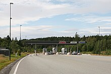
The section from Bjørnstad in Røyken to Vassum was built at the same time as the tunnel and is referred to as the Oslofjord Link (Norwegian: Oslofjordforbindelsen).
[16] It attempted to revitalize the proposal and launched a detailed plan in 1974 which called for two bridges which would connect each side of the fjord to the island of Håøya.
The plans were rejected by the road administration because of the steep cost and low traffic prognosis, while others criticized the environmental impact it would create on Håøya and at the towns of Svelvik and Drøbak.
Also the construction of a new plant at Tofte Cellulosefabrikk was expected to give a large rise in lumber transport to the region and could contribute to cross-fjord traffic.
Across Vestfjorden the road would cross on another three-pylon cable-stayed bridge with main spans of 590 and 530 meters (1,940 and 1,740 ft), with the central pylon placed on Stedgrunnen.
[23] The bridge could also serve as possible route for the Hurum Line, a railway which was proposed to link the new airport to the capital.
Without the airport traffic, the profitability in the project fell through and the Public Roads Administration called to instead prioritize other investments.
However, Minister of Transport and Communications Kjell Opseth was a staunch supporter of the Oslofjord Link, in part as a compensation for the loss of the airport after it in 1992 was decided to be built at Gardermoen.
[16] The Public Roads Administration landed in 1992 at a bridge alternative as their preferred solution,[30] backed among others by the Norwegian Haulier’s Association and Hurum Municipality.
[31] On the other hand, the bridge was met with protests from environmental organizations and residents of Drøbak and the ministry thus decided to go for a tunnel.
[30] Opseth announced in January 1994 that he favored a tunnel over a bridge, stating that decisive weight had been laid on costs.
[39] The contract for blasting the tunnel, worth NOK 347 million, was awarded to Scandinavian Rock Group.
[48] On the other hand, the tunnel was the first to receive a system which automatically detects vehicles carrying hazardous materials and can inform the fire departments of all of them should an incident occur.
[40] The tunnel flooded on 16 August 2003 after the automatic pumping system failed to sufficiently drain the natural reservoir for water.
This caused the pumps to malfunction and it took a week to drain the tunnel for 3,000 cubic meters (110,000 cu ft) of water and allow it to open.
[51] Further surveys revealed that the geological evaluations during construction had overestimated the quality of the rock and hence not implemented sufficient countermeasures.
[56] As a temporary measure, two morning and two afternoon rush-hour free ferries were put into service between Drøbak and Sætre.
[59] From March 2012 the weight restriction was lifted, but instead replaced by a length limitation of 12 meters (39 ft), in an attempt to allow smaller commercial vehicles to use the tunnel.
[60] To cover necessary upgraded to improve the tunnel's safety, Parliament awarded a grant of NOK 40 million in May.
[62] With these installations in place the Public Roads Administration hoped to re-open the tunnel for heavy traffic, but the decision was vetoed by Southern Follo Fire Department.
[64] In March 2012 the Public Roads Administration, based on the plans to build a second tube, announced a prolonging of the toll period, initially with another three years.
In addition the tolls would stimulate for less traffic through the tunnel, which the agency wanted to reduce until a second tube opens.
[67] This design was built into the original plans, in which the road administration anticipated building the crossing as a full motorway in two phases.
The second tube will have to closely follow the route of the current tunnel, thus eliminating the possibility of a less steep gradient.
[71] The second involves a suspension bridge to be built further south in Drøbaksundet, from Vestby, estimated to cost NOK 10 billion.