Outer Banks
A major tourist destination, the Outer Banks are known for their wide expanse of open beachfront and Cape Hatteras National Seashore.
[1] The seashore and surrounding ecosystem are important biodiversity zones, including beach grasses and shrubland that help maintain the form of the land.
The Outer Banks were also home to the Wright brothers' first flight in a controlled, powered, heavier-than-air vehicle on December 17, 1903, at Kill Devil Hills.
A tall ridge of sand dunes that survived the melting of the Earth's glaciers gave rise to the barrier islands that make up the Outer Banks.
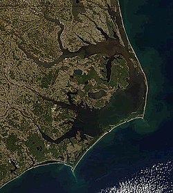
The Outer Banks is a string of peninsulas and barrier islands separating the Atlantic Ocean from mainland North Carolina.
[12] It is separated by the Currituck Sound and the Intracoastal Waterway, which passes through the Great Dismal Swamp occupying much of the mainland west of the Outer Banks.
North Carolina State Highway 12 links most of the popular Outer Banks communities in this section of the coast.
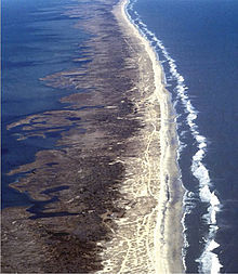
The Outer Banks are not anchored to offshore coral reefs like some other barrier islands, and as a consequence, they often suffer significant beach erosion during major storms.
William B. Umstead Bridge, the second oldest (built in 1957, rehabilitated in 1966), carries US 64 between Manns Harbor on the mainland and Manteo on Roanoke Island.
Additionally, NC 615 serves as the main route along Knotts Island in the extreme north; it connects only to Virginia by land.
The vegetation of the Outer Banks has biodiversity, although it is considered the northern limit for many southern plants such as wild scrub palms.
[16] The Outer Banks are home to Yaupon Holly (Ilex vomitoria), the roasted leaves of which were brewed into a high caffeine beverage called black drink by the Native Americans.
[17] The islands are home to herds of feral horses, sometimes called "banker ponies", which according to local legend are descended from Spanish mustangs washed ashore centuries ago in shipwrecks.
As the islands jut out from the eastern seaboard into the Atlantic Gulf Stream, the Outer Banks have a predisposition to be affected by hurricanes, Nor'easters (usually in the form of rain, and rarely snow or mixed precipitation), and other ocean-driven storms.
The winters are typically milder than in inland areas, averaging lows in the upper 30s and highs in the lower 50s, and are more frequently overcast than in the summer.
The fall and winter are usually warmer than areas inland, and the spring and summer are often slightly cooler because of the moderating effects of being surrounded by water.
Some residents of the Outer Banks, known as wreckers, made part of their living by scavenging wrecked ships—or by luring ships to their destruction.
[23] In the mid-19th century, large-scale commercial fishing erupted, mostly due to the construction of the Albemarle and Chesapeake Canal, which simplified shipping methods for fishermen.
[24] Anglers, otherwise known as fishermen, have a wide range of fishing methods, some dating back to when the first settlers arrived, to choose from in the Outer Banks.