Outline of Chile

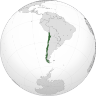
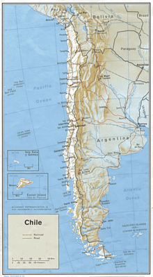
The following outline is provided as an overview of and topical guide to Chile: Chile – country in South America occupying a long, narrow strip of land between the Andes mountains to the east and the Pacific Ocean to the west.

Prior to the arrival of the Spanish in the 16th century, northern and central Chile was under Inca rule while independent Mapuche inhabited south-central Chile.

Chile declared its independence from Spain on 12 February 1818.

Today Chile is one of South America's most stable and prosperous nations, a recognized middle power, and an emerging economy.

Geography of Chile List of ecoregions in Chile Administrative divisions of Chile List of cities in Chile Demographics of Chile Politics of Chile Government of Chile Court system of Chile Foreign relations of Chile The Republic of Chile is a member of:[1]

An enlargeable relief map of Chile
Click over the map to obtain a topographic map of the region and its toponymy File:SRTM-W70.50E68.80S19.00N17.40.Arica.png File:SRTM-W70.50E68.34S20.00N19.00.Pisagua.png File:SRTM-W70.33E68.34S21.00N19.00.Iquique.png File:SRTM-W70.33E67.34S22.00N21.00.Quillagua.png File:SRTM-W70.50E67.00S23.00N22.00.Calama.png File:SRTM-S24.00N23.00W070.80E067.00.Antofagasta.png File:SRTM-W70.66E67.00S25.00N24.00.Paranal.png File:SRTM-W71.00E68.30S26.00N25.00.Taltal.png File:SRTM-W71.00E68.10S27.00N26.00.Salvador.png File:SRTM-W71.30E68.00S28.00N27.00.Copiapo.png File:SRTM-W71.60E69.20S29.00N28.00.Vallenar.png File:SRTM-W71.70E69.70S30.00N29.00.LaSerena.png File:SRTM-W71.90E69.70S31.00N30.00.Ovalle.png File:SRTM-W71.70E71.20S32.00N31.00.Illapel.png File:SRTM-W71.70E69.90S33.00N32.00.Quillota.png File:SRTM-W72.00E69.70S34.00N33.00.Talagante.png File:SRTM-W72.30E69.70S35.00N34.00.Chimbarongo.png File:SRTM-W73.00E70.00S36.00N35.00.Talca.png File:SRTM-W73.30E70.33S37.00N36.00.Chillan.png File:SRTM-W74.00E71.00S38.00N37.00.Nacimiento.png File:SRTM-W74.00E70.70S39.00N38.00.Temuco.png File:SRTM-W73.75E71.33S40.00N39.00.Valdivia.png File:SRTM-W74.00E71.50S41.00N40.00.Osorno.png File:SRTM-W74.20E71.70S42.00N41.00.PuertoMontt.png File:SRTM-W74.30E71.70S43.00N42.00.Chiloe.png File:SRTM-W75.00E71.50S44.00N43.00.Melinka.png File:SRTM-W75.00E71.00S45.00N44.00.Puyuguapi.png File:SRTM-W75.10E71.25S46.00N45.00.Coihaique.png File:SRTM-W75.80E71.50S47.00N46.00.Chilechico.png File:SRTM-W75.50E71.70S48.00N47.00.Cochrane.png File:SRTM-W75.90E72.00S49.00N48.00.VillaOHiggins.png File:SRTM-W75.90E72.00S50.00N49.00.PuertoEden.png File:SRTM-W75.66E72.00S51.00N50.00.IslaMadredeDios.png File:SRTM-W75.40E71.80S52.00N51.00.PuertoNatales.png File:SRTM-W75.10E68.33S53.00N52.00.PuntaDelgada.png File:SRTM-W74.50E68.33S54.00N53.00.PuntaArenas.png File:SRTM-W73.50E68.33S55.00N54.00.IslaNoir.png File:SRTM-W72.00E66.00S56.00N54.70.CanalBeagle.png
Click over the map to obtain a topographic map of the region and its toponymy.
An enlargeable satellite image of Chile