Outline of the Sahrawi Arab Democratic Republic
The following outline is provided as an overview of and topical guide to the Sahrawi Arab Democratic Republic: Sahrawi Arab Democratic Republic (SADR) – partially recognised state that claims sovereignty over the entire territory of Western Sahara, is a former Spanish colony.
The SADR was proclaimed by the Polisario Front on February 27, 1976, in Bir Lehlou, Western Sahara.
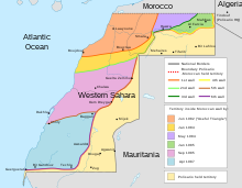
The SADR government controls about 20-25% of the territory it claims.
Morocco controls and administers the rest of the disputed territory and calls this area its Southern Provinces.
Geography of the Sahrawi Arab Democratic Republic Environment of Western Sahara Landforms in Western Sahara Regions of Western Sahara Politics of the Sahrawi Arab Democratic Republic Politics of Western Sahara Government of the Sahrawi Arab Democratic Republic Foreign relations of the Sahrawi Arab Democratic Republic Law of Western Sahara Military of the Sahrawi Arab Democratic Republic History of Western Sahara Demographics of Western Sahara Culture of Western Sahara Sports in Western Sahara Economy of Western Sahara Communications in Western Sahara Education in Western Sahara Wikimedia Atlas of the Sahrawi Arab Democratic Republic