Oxkintok
Oxkintok is a pre-Columbian Maya archaeological site in the Puuc region of Yucatán state, in southeastern Mexico.
This means no major river systems and hardly any lakes are present in the northern Yucatán as the limestone lithology drains subterraneously.
The underground drainage results in the northern Yucatán being covered in caves and sinkholes called cenotes, which are subsequently used by the inhabitants to access drinkable ground water.
Any relief in the Puuc region is due to unequal dissolution rates within the limestone bedrock, and never reaches 400 meters above sea level.
In the Yucatec Maya language, the name "Oxkintok" can be parsed as "Ox" (three) and "Kin" (day/sun), but there are multiple possibilities for "Tok" (if the final letter is a soft /K/ then it may mean "snatch away / defend, lean, fall, or burn", but if the final letter is truly a glottalized /K’/ then it may mean "puncture, let blood, or chert / flint / hard stone").
He was also first to make note of Satunsat "the place where they tossed those who had committed great offenses so that there they may die" (Torecilla, 1998).
Between 1932 and 1940 the Carnegie institution of Washington funded a large project to collect data on many sites of the Yucatán peninsula (Torecilla, 1998).
Since the 1980s a long-term project directed by Miguel Rivera Dorado (of Madrid, Spain) has produced a vast amount of data on Oxkintok.
Most recently, Mexico's INAH has invested in excavations and reconstructions at the site (under the direction of Ricardo Velazquez Valadez).
The Noheb phase lines up with the Middle Classic and during this period, polychrome pottery disappears along with any sort of stone inscriptions, and the construction of large pyramids begins.
The Nak phase is a high point, with the building of the most 'glamorous' architecture, and Pre-pizarran ceramics emerge, characterized by supporting conical feet but displaying a broad diversity in design otherwise.
Finally the Tokoy phase is defined by a disappearance in all evidence of human activity, except for pottery with a deterioration in materials and in consistency in technique, which fades out completely towards 1500 CE.
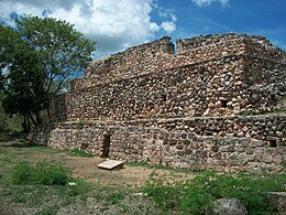
The site is used as an example of the transition from traditional Classic Period architecture to Puuc Veneer masonry by George F. Andrews.
There's no real guess as to what it was built for, though there was a recent discovery that most of the ventilation shafts line up with specific positions of the sun, so some think it was a maze used for initiation and practice of religion but there's nothing conclusive.
The Dzib group was specialized, possessing a ball court making it extremely important in the expression of social order, power relations, and legitimization of monarchy (Dorado, 1996).
Looking at the orientation of buildings, such as the facades of Satunsat that face east and west it is specially prepared for observing the solar equinox and trapping sunlight in the interior of the labyrinth (Dorado, 1996).
In the Ah Canul group, effigies to the sun and the moon and images of the "governing family" referred to as Walas can still be seen, further interlinking these two aspects of Mayan culture at Oxkintok.
Dorado (1996) presents the idea that continual construction that took place at Oxkintok and other Maya sites is related to the symbolization of kinship ties and the cult of ancestors.
Construction is the affirmation and expression of kinship ties and laws of stratification, so each building reaffirms a lineage, the memory of its existence and the justification of its power.
Discussion of leadership and inequality revolves around the site's architecture as many of Oxkintok's excavations have been focused on the design of its urban center and its development during antiquity (Dorado, 1997).
It is hard however to separate the government structure from what is known of the religion at Oxkintok: "The layout of the city seems to have been related to the movements of the sun and the political power of the leader (Manzanilla, 1997)".
Manzanilla (1997) also states the Dorado stresses the difficulty of maintaining widespread territorial control in the tropical rainforest and that strength is based on kinship ties.
The stelae at the site are illegible/uninterpretable do to advanced erosion and deterioration, but can be without doubt placed in the late classic period by other characteristics (Dorado, 1996).
It is also important to note that there was a conspicuous "hiatus" of writing at Oxkintok during a boom in architectural contraction at the site, 550-650AD (Dorado, 1996).
It is accessible from the nearby town of Maxcanú, approximately 62 km (38.5 mi) south of Mérida on Federal Highway 180.