Oxley Wild Rivers National Park
[5] For thousands of years, the Northern Tablelands and these valleys were the tribal lands of the Dangaddi aboriginal people, whose descendants are now concentrated in the lower Macleay River.
After Oxley passed through the cedar-getters were the first white people to penetrate these remote gorges and valleys in search of Australian red cedar (Toona ciliata) which was floated down-river to Kempsey.
With future land-use undecided, the NSW Electricity Commission began surveying the Apsley Valley for a hydro-electric scheme in the late 1970s.
Further inclusions include Green Gully headwaters and 1,439 hectares (3,560 acres) of leasehold land in the lower Chandler River gorge.
The Macleay Gorges Wilderness Area was declared in 1996 and extended in 1997 and covers over 50,000 hectares (120,000 acres), mainly in the central part of the park.
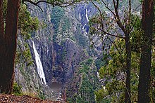
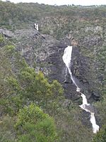
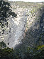
[6] The Oxley Wild Rivers National Park lies along the Great Escarpment between the Northern Tablelands, and the east coast and has dramatic gorges and waterfalls, extensive wilderness and dry rainforest.
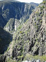
The formation of the area began with muddy sediments under ancient oceans that were changed by heat and pressure into hard rocks, then uplifted by movements of the continental plate and volcanic eruptions.
This resulted in the formation of the Great Dividing Range, an undulating plateau that sloped gently to the west and fell away steeply to the east.
The jagged scarp is slowly retreating west and this movement can be seen today in the erosion of steep cliffs at places like Wollomombi, Dangars and Apsley Gorges.
The Apsley Macleay Gorges are a converging point for moister eastern coastal and dry western floras, and some 950 native plant species have been identified, of which 36 are rare or threatened.
[7] Dry rainforests in the OWRNP contain at least 187 plant species and they are visible as dense, dark green patches of brush box (Lophostemon confertus), favouring hollows where there is shelter from wind and sun.
Other plants that could be found in or around dry rainforests include: native rosella (Hibiscus heterophyllus), gorge mock-olive (Notelaea microcarpa), Brachychiton discolor (lacebark), Moreton Bay fig (Ficus macrophylla), native olive (Olea paniculata), red kamala (Mallotus philippensis), scentless rosewood (Synoum glandulosum)[8] and shatterwood (Backhousia sciadophora).
Eucalyptus tereticornis (forest red gum) identified by the bark on its trunk which sheds to expose white, grey or bluish patches may also be seen, too.
Smilax australis (lawyer vine or wait-a-while) is another plant to be avoided as it has prickly climbing stems that are up to eight metres long and will catch in clothing or the skin.
The understorey is often sparse except for occasional Acacia (wattles), Bursaria spinosa (blackthorn), Xanthorrhoea (grass trees) and The cassinia, geebung (Persoonia spp.
Oxley Wild Rivers National Park is a major refuge for the brush-tailed rock-wallaby (Petrogale pencillata), with the largest confirmed population in the Green Gully area of Yarrowitch.
Quolls, common brushtail possums, sugar gliders, platypus, echidnas, wedge-tailed eagles, peregrine falcons and dingoes may also be seen.
Notable, is the speckled longfin eel (Anguilla reinhardtii), which breeds in the ocean with the juveniles eventually returning to the Apsley–Macleay River system.
There are five mammals (brush-tailed phascogale, brush-tailed rock wallaby, koala, squirrel glider and tiger quoll); four birds (glossy black cockatoo, greater sooty owl, superb fruit-dove and turquoise parrot); one reptile (Morelia spilota variegata (carpet python)); and two frogs (Litoria piperata and Litoria subglandulosa).
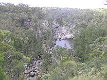
Here the Northern Tablelands plateau drops precipitously into the rugged gorges carved out by the Aspley and upper Macleay Rivers which meander through the park.
Budds Mare is set in bushland and a short walk takes you to the lookout which has extensive views over Gondwana dry rainforest in the Apsley River Gorge.
There is a good 8-kilometre (5.0 mi) walk from here down the ridge to the Riverside Visitor Area on the Apsley River, but it is only for well prepared bushwalkers with a sound knowledge of steep country.
[citation needed] Facilities include drinking water, toilets, a shelter shed and fireplace and bush camp sites for overnight stays.
Facilities include a carpark, shelter shed with fireplace, picnic tables with small wood barbecues, tank water, pit toilets, an information display and bush camping with firewood supplied.
The Riverside Rest Area is on the banks of the Apsley River, 50 kilometres (31 mi) east of Walcha and is reached by the Moona Plains Road.
A 4WD vehicle is needed to access Marys View, from outside the national park, and it is at least a seven–hour return trip from either Walcha or Armidale and onto the Carrai tableland.
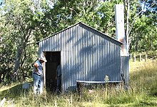
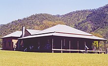
The historic, remote Middle Yards Hut, located on Kunderang Brook deep within Oxley Wild Rivers National Park, has been restored to its original condition by the NPWS.
A holding yard for horse trekkers was constructed here, along with a hitching rail, period furniture inside the hut, an outdoor barbecue and new water tank.
The 5-kilometre (3.1 mi) Threlfall Walk follows the route of the historic 1894 hydro-electric scheme, along old embankments and through ancient cuttings, to a lookout platform high above the river.
Lantana was widely distributed in warmer lower areas of the park and also invaded rainforest thickets, where it has affected World Heritage values.