Pacific Rim National Park Reserve
For recreational purposes, Long Beach is used for surfing and windsurfing, the Broken Group for sea kayaking, and the West Coast Trail for hiking, as well as camping in all areas and scuba diving in the winter months in the Long Beach and Broken Group areas.
Bennett, a breakthrough was reached after Jean Chrétien took over for Arthur Laing as the federal minister responsible for parks.
Reconnaissance trips by government representatives, one of them being Hugh Llewellyn Keenleyside, found insufficient rationale for establishing a park there at that time, due to its remote and inaccessible location, outstanding forestry encumbrances, and with respect to its development as a health resort–type park, its cold waters, and fog, among other reasons.
The highway resulted in thousands of new visitors descending on the beaches each year throughout the 1960s, including for international surfing competitions from 1966 to 1968.
This led to a plundering of the foreshore for food and souvenirs, building temporary shacks from driftwood, improvised latrines, and left-behind garbage and vehicles sunk in the sand.
The project would only advance after 1968 when Jean Chrétien replaced Laing, as Pierre Trudeau succeeded Lester B. Pearson as prime-minister.
Related to the Pacific Rim National Park Reserve, the Nuu-chah-nulth Tribal Council had submitted a claim in 1980 which the government accepted for negotiation in June 1983.
Beginning in 1995 the First Nations Program resulted in the creation of the Nuu-chah-nulth interpretative trail, cultural information included in educational literature and displays, increased employment in park services, and shared management responsibilities.
In the Long Beach area where the Tla-o-qui-aht claim traditional territory, they have declared the entire Kennedy Lake watershed, as well as Meares Island, as a tribal park.
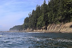
Based on its landscape and habitat diversity, Parks Canada characterizes this region as Canada's rocky west coast created by crustal material moving eastward creating coastal mountains, deep fiords and channels carved by the release of water from retreating glaciers, and experiencing heavy rainfall and mild temperatures resulting in temperate rain forests.
Its boat launch can be used for paddling around the bay or to access the Clayoquot Sound or the Browning Passage around the Esowista Peninsula to the ocean.
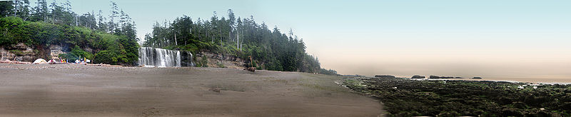
The area is predominantly marine with high-relief rock reefs and kelp beds anchored by a rocky substrate.
Other marine vessels pass through the area but Parks Canada prohibits motorboats from landing on islands with campsites.
[13] After the disaster of the American steamship SS Valencia, in 1906 with 37 survivors reaching shore along the telegraph line, the federal government upgraded the corridor to act as a trail with several shelters along the way.
[14] Eventually the provincial government sold the timber rights but following advocacy by Sierra Club Canada and locals, the BC Parks branch placed a reserve, in 1964, around the trail which outdoor enthusiasts had continued using.
Sympathetic with the logging interests, the provincial government resisted but it was included in the 1970 agreement with its specific boundaries to be determined.
The prevailing jet stream brings low pressure systems off the ocean from the Gulf of Alaska in the winter.
Its cool, moist air mass experience orographic lift as it immediately rises through the mountains and deposits large quantities of precipitation.
The terrestrial portion of the park lies within what the province terms the Coastal Western Hemlock Biogeoclimatic Zone (very wet hypermaritime subzone), based on the climax vegetation.
The forest is home to black bears, Vancouver Island cougar, Roosevelt elk, and marten, as well as numerous invertebrates like the banana slug and warty jumping-slug and birds like the marbled murrelet and the olive-sided flycatcher.
Cutthroat trout, red-legged frog, western toad, mink and river otter live in the lakes and wetland areas.