California county routes in zone G
From the southern end of G1 on Fremont Peak as San Juan Canyon Road, G1 begins a steep, sharp-curved winding descent from around 3,000 feet for the first 2 miles, north to northeast.
At the intersection of Mission Vineyard Road, G1 becomes The Alameda, which then heads north for approximately 1/4 mile before reaching the northern terminus at State Route 156.
County Route G2 (CR G2), more commonly known as Lawrence Expressway and Quito Road, is a busy 9.7-mile (15.6 km) long north–south link through Silicon Valley in Northern California.
Oregon Expressway functions more comparably to a County-maintained Arterial Road for Palo Alto, with frequent signaled intersections and a posted speed limit of 35 MPH.
Other than a commemorative sign, no artifacts remain at the mill site, which is accessible only by Slate Creek Trail from either Portola Redwoods state park or from Skyline Boulevard (SR 35).
[9] When the underpass is closed due to flooding, through traffic must detour onto Alma Street (Route G6) and cross the train tracks at either Churchill Ave to the North, or Charleston Rd to the south.
When Interstate 280 was completed through the area in 1969, the old narrow Page Mill road, which passed by the Frenchman's Tower, was bypassed over the hills to the south and expanded to 5 lanes from 2.
In 2014, the county began a rehabilitation project on Oregon Expressway, which entailed rebuilding and landscaping of the center median, installation of new traffic lights and mast arms, and repaving of the travel lanes.
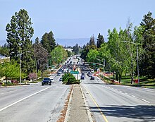
It connects Palo Alto to the Silicon Valley proper closely paralleling Interstate 280 through the lower Santa Cruz Mountains foothills.
It proceeds northwest directly east of I-280 making it a viable alternative route for short trips between Cupertino and Palo Alto.
In 1970, one of the first scientifically designed noise barriers in the nation was conceived for Foothill Expressway in a study overseen by the Santa Clara County Public Works Department using Sunnyvale consultant ESL Inc.
In 2021, Route G5 saw one of its only major expansions from since it was first built; the section of Foothill between San Antonio Road and El Monte Avenue was widened from 4 lanes to 6, complete with removal of the dedicated right-turn ramps and installation of new traffic signals.
It consists mainly of Central Expressway, along with portions of Alma Street in Palo Alto and De La Cruz Boulevard in San Jose.
At the Palo Alto – Mountain View border at San Antonio Road, CR G6's character changes, removing the driveways and frequent intersections and adding a center divider, and is known as Central Expressway.
Up to this point, the roadway has paralleled the Caltrain rail line all the way from the Palo Alto station, which limits the intersections on the south side of the road.
Through this section, Central Expressway has a wide center divider with guardrails, and access is limited to a sequence of several separated grade interchanges at main cross streets with no turnoffs or driveways.
In 2007, construction was completed near the eastern terminus widening Central Expressway to accommodate an HOV lane and a reconfiguration of the intersection with Lafayette Street.
The road is still closed to this day, and the turn pockets onto Castro Street from Central remain coned off while the city and county determine more permanent plans for this intersection.
County Route G10 (CR G10), known as Los Gatos-Saratoga Road, Los Gatos Boulevard, and more commonly known along the majority of its route as Blossom Hill Road for the majority of its length, is an important east–west arterial roadway through the Almaden Valley area of Santa Clara County, California, United States in the Silicon Valley.
CR G10 proceeds as a busy 4-6 lane artery through this area, intersecting Almaden Expressway and further east, through the Blossom Valley neighborhood of San Jose, to SR 85.
Prior to the completion of the segments of SR 85 between 1991 and 1994, which CR G10 roughly parallels, Blossom Hill Road was the major accessway to this area of San Jose from the west.
G13 then enters a hilly area before crossing into San Benito County for an additional 6 miles (10 km) and terminating at the junction of State Route 25 at Bitterwater.
CR G14 connects with Lake Nacimiento, Fort Hunter Liggett, and the Mission San Antonio de Padua, as well as the town of Jolon.
Just a few hundred feet (~100 meters) south of Lockwood, G14 reaches the intersection of the western terminus of CR G18 and heads west along Jolon Road.
As G14 reaches the small town of Jolon, a side road provides an entrance to the Fort Hunter Liggett military facility while G14 curves to the north.
The road parallels US 101 (and therefore El Camino Real) between King City and Soledad, with 101 to the west of the Salinas River and G15 to the east and following the western foot of the Gabilan Range.
G15 follows this road 17 miles (27 km) northwestward, bypassing Greenfield for the unincorporated community of Metz and terminating at State Route 146 near Soledad.
At Del Monte Boulevard, G17 truncates back to a 2-lane city street, progressively turning north, with traffic circles until the intersection of Beach Road.
County Route G19 begins at its southern terminus at Interlake Road, which is a continuation of the CR G14 portion of Nacimiento Lake Drive.
G19 then follows northeast along the San Antonio River for approximately one mile (1.6 km) before continuing north to the end at CR G18, a few hundred feet (30.48 meters) from U.S. Route 101 near Bradley.