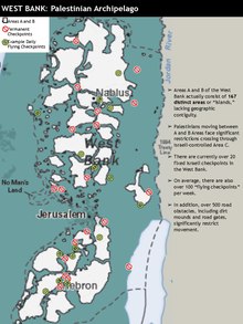
Palestinian enclaves
[j] The consequences of the creation of these fragmented Palestinian areas has been studied widely, and has been shown to have had a "devastating impact on the economy, social networks, [and] the provision of basic services such as healthcare and education".
[s] Other Israelis and Americans who have used similar terminology in various contexts include Ariel Sharon (reportedly),[t] Colin Powell,[19] James Baker,[u] John Dugard,[20] Martin Indyk,[v] Daniel Levy,[21] Amos Elon,[22] Yigal Allon,[23] I. F. Stone,[w] Avi Primor,[24] Ze'ev Schiff,[25] Meron Benvenisti,[26] Yuval Shany,[27] Menachem Klein,[28] and Akiva Eldar.
[32] After the 1967 Six-Day War, a small group of officers and senior Israeli officials advocated that Israel unilaterally plan for a Palestinian mini-state or "canton", in the north of the West Bank.
[s] Just weeks after the war, American Jewish intellectual I. F. Stone wrote that giving the West Bank back to Jordan would be better than creating "a puppet state — a kind of Arab Bantustan".
Pursuant to this and subsequent plans, twelve Israeli settlements were established in such a way as to "complete a belt of built fabric that enveloped and bisected the Palestinian neighborhoods and villages annexed to the city.
The third stage included Pisgat Ze'ev in 1980 and the creation of the "outer security belt", which consisted of Ma'ale Adumim (1977), Givon (1981) and Efrat (1983), built on high ground and next to strategic roads in the Palestinian area.
[49] According to Avi Primor, the former deputy director-general of Israel's Foreign Ministry's department for Africa, Asia and Oceania, who was an ambassador and vice president of Tel Aviv University at the time of writing in 2002, in the top echelons of the Israeli security establishment in the 1970s and 1980s there was widespread empathy for South Africa's apartheid system and it was particularly interested in that country's resolution of the demographic issue by inventing bantustan "homelands" for various groups of the indigenous black population.
[54] In late 1984, some embarrassment was caused when the Israeli settlement of Ariel in the West Bank paired itself as a sister city with Bisho, the capital of the ostensibly independent Bantustan of Ciskei.
[57] In 1985, the National Conference of Black Lawyers in the United States compiled a report, entitled Bantustans in the Holy Land, making the analogy with what was taking place in the West Bank.
but 15 years later, an American comparative law scholar and Africanist, Adrien Wing wrote that events in the ensuing decade and a half regarding the way territory was being regulated seemed to support the cogency of the analogy.
[60] The Intifada lost impetus after the Madrid Conference of 1991 that brought together Israeli and Palestinian representatives for the first time since 1949 and in 1992, Rabin pledged to halt settlement expansion and began secret talks with the PLO.
[61] Soon after the joint signing of the Oslo I Accord on 13 September 1993, Yassir Arafat and Shimon Peres engaged in follow-up negotiations at the UNESCO summit held in December that year in Granada.
Arafat was incensed at what he saw as the impossible terms rigidly set by Peres regarding Israeli control of border exits with Jordan, stating that what he was being asked to sign off on resembled a bantustan.
Late one night during the negotiations, my commander took me from the hotel where the talks were taking place to an army base, where he led me to a room with large fluorescent light tables and piles of maps everywhere.
[73] He did draw an analogy however between the two situations by saying that the peace negotiations had led to a corrupt elite, the Palestinian Authority, playing a role similar to that of the black leadership appointed by South Africa to administer their Bantustans.
[al][am][an][74] Israel Prime Minister Ehud Barak's offer was widely reported as "generous" and, according to participant Dennis Ross would have handed control over 97% of the West Bank to Palestinians.
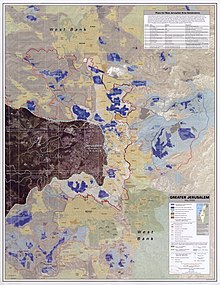
In addition, there are other large areas that would have been taken or earmarked to be used exclusively by Israel, roadways that connect the settlements to one another and to Jerusalem, and 'life arteries' that provide the settlers with water, sewage, electricity, and communications.
About one hundred military checkpoints completely surround Palestine and block routes going into or between Palestinian communities, combined with an uncountable number of other roads that are permanently closed with large concrete cubes or mounds of earth and rocks.
Another Israeli guest, who was present at the dinner and who was (deeply) involved in cultivating ties between Israel and South Africa, confirmed that "whenever he happened to encounter Sharon, he would be interrogated at length about the history of the protectorates and their structures.
[aq] Not only was the Gaza Strip to be reduced to a bantustan, but the model there, according to Meron Benvenisti, was to be transposed to the West Bank by ensuring, simultaneously, that the Separation Wall itself broke up into three fragmented entities: Jenin-Nablus, Bethlehem-Hebron and Ramallah.
Avi Primor in 2002 described the implications of the plan thus: "Without anyone taking notice, a process is underway establishing a 'Palestinian state' limited to the Palestinian cities, a 'state' comprisedof a number of separate, sovereign-less enclaves, with no resources for self-sustenance.
"[as] Commenting on these plans in 2006, Elisha Efrat, Professor of urban geography at TAU argued that any state created on these fragmented divisions would be neither economically viable nor amenable to administration.
[at] In a 26 May 2005 joint press conference with Mahmoud Abbas, in the White House Rose Garden, President George W. Bush stated his expectations vis-a-vis the Roadmap Plan as follows:[88] Any final status agreement must be reached between the two parties, and changes to the 1949 Armistice lines must be mutually agreed to.
[91] By 2005, together with the Separation Wall, that area had been potted with 605 closure barriers whose overall effect was to create a "matrix of contained quadrants controllable from well-defended, fixed military positions and settlements".
"[94] In a 2016 interview, former Israeli Member of Knesset (MK) Ksenia Svetlova argued that West Bank disengagement would be very difficult and that a more likely outcome was "annexation and controlling Palestinians in Bantustans".
"[11] According to Professor Ian Lustick, the appellation "State of Palestine" applied to this archipelago of Palestinian-inhabited districts is not to be taken any more seriously than the international community took apartheid South Africa's description of the bantustans of Transkei, Bophuthatswana, Venda, and Ciskei as "independent nation-states.
[6] A group of human rights experts also sided with the opinion, saying that "what would be left of the West Bank would be a Palestinian Bantustan, islands of disconnected land completely surrounded by Israel and with no territorial connection to the outside world.
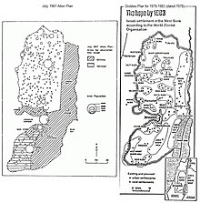
The Drobles plan made this explicit:[118] The purpose of settling the areas between and around the centers occupied by the minorities is to reduce to the minimum the danger of an additional Arab state being established in these territories.
Being cut off by Jewish settlements the minority population will find it difficult to form a territorial and political community.Post-Oslo closure and separation (hafrada) policies are manifested in checkpoints, bypass roads, The Wall, and the permit system.
"[v] In 2003, Special Rapporteur on the Right to Food Jean Ziegler reported that he was: also particularly concerned by the pattern of land confiscation, which many Israeli and Palestinian intellectuals and non-governmental organizations have suggested is inspired by an underlying strategy of "Bantustanization".