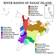
Panay
Coming from the root word "simsim", "simsimin" means "to lick something to eat or to drink", thus the place was called Simsiman.
The native Ati called the island Aninipay from words "ani" to harvest and "nipay", a hairy grass abundant in the whole Panay.
According to Maragtas, the Confederation of Madja-as was founded after ten datus fled Borneo and landed on Panay Island.
An old manuscript Margitas of uncertain date (discovered by the anthropologist H. Otley Beyer)[12] gives interesting details about the laws, government, social customs, and religious beliefs of the early Visayans, who settled Panay within the first half of the thirteenth century.
On 5 June 1569, Guido de Lavezaris, the royal treasurer in the Archipelago, wrote to Philip II reporting about the Portuguese attack to Cebu in the preceding autumn.
A letter from another official, Andres de Mirandaola (dated three days later, 8 June), also described briefly this encounter with the Portuguese.
The danger of another attack led the Spaniards to remove their camp from Cebu to Panay, which they considered a safer place.
Legazpi himself, in his report to the Viceroy in New Spain (dated 1 July 1569), mentioned the same reason for the relocation of Spaniards to Panay.
[…] It is very beautiful, very pleasant, and full of coconut palms… Near the river Alaguer (Halaur), which empties into the sea two leagues from the town of Dumangas…, in the ancient times, there was a trading center and a court of the most illustrious nobility in the whole island.
"[18] Padre Francisco Colin (1592–1660), an early Jesuit missionary and Provincial of his Order in the Philippines also records in the chronicles of the Society of Jesus (published later in 1663 as Labor euangelica) that Panay is the island which is most abundant and fertile.
[21] Miguel de Luarca, who was among the first Spanish settlers in the Island, made one of the earliest account about Panay and its people according to a Westerner's point of view.
"[22] "The natives are healthy and clean, and although the island of Cebu is also healthful and had a good climate, most of its inhabitants are always afflicted with the itch and buboes.
"As the island contains great abundance of timber and provisions, it has almost continuously had a shipyard on it, as is the case of the town of Arévalo, for galleys and fragatas.
Their customary method of trading was by bartering one thing for another, such as food, cloth, cattle, fowls, lands, houses, fields, slaves, fishing-grounds, and palm-trees (both nipa and wild).
On 5 June 1569, Guido de Lavezaris, the royal treasurer in the Archipelago, wrote to Philip II reporting about the Portuguese attack to Cebu in the preceding autumn.
A letter from another official, Andres de Mirandaola (dated three days later - 8 June), also described briefly this encounter with the Portuguese.
The danger of another attack led the Spaniards to remove their camp from Cebu to Panay, which they considered a safer place.
Legazpi himself, in his report to the Viceroy in New Spain (dated 1 July 1569), mentioned the same reason for the relocation of Spaniards to Panay.
In 1716, Capiz was organized into a separate politico-military province with the transfer of the capital from the town of Panay, Under its jurisdiction were the neighboring islands of Campo, Romblon, Tablas, and Sibuyan.
In 1853, The island now comprising Romblon province and Maestre de Campo was organized into separate politico-military “comandancia” administered from Capiz.
Guerrilla forces under Colonel Macario Peralta Jr. later liberated most of the island and eventually captured the city of Capiz on December 20, 1944.
The original towns were Altavas, Balete, Batan, Banga, Buruanga, Ibajay, Kalibo, Lezo, Libacao, Madalag, Malay, Makato, Malinao, Nabas, New Washington, Numancia, and Tangalan, then all part of the province of Capiz.
[1] Mount Madja-as is the highest point in Panay with an elevation of 2,117 metres (6,946 ft) above sea level,[2] located in town of Culasi in the northern province of Antique.
The diversity of industries, including agriculture, fishing, tourism, manufacturing, and natural resource utilization, sustains the island's robust economic growth and development.
[38] Capiz, dubbed the "Seafood Capital of the Philippines," takes advantage of its coastal areas and swampy lands, supporting a thriving fishing industry.
The province's aquamarine resources, including prawns, milkfish, marlin, squid, oysters, shrimp, and seaweed, contribute significantly to its economic growth.
Additionally, the province's forest resources, such as bamboo, buri, bariw, nito, logs, and charcoal, contribute to the construction industry, furniture-making, and handicrafts.
The natural beauty of Antique, including the presence of the rafflesia flower and protected forestland, further enhances its tourism potential.
Proposals to re-connect again Iloilo-Roxas, Iloilo-Kalibo, Iloilo-Malay (Aklan) and Iloilo-San Jose (Antique) from the Iloilo City via rail was included in the revival of the currently defunct Panay Railways network which has a station in Santa Barbara town proper.