Parinacota (volcano)
Part of the Central Volcanic Zone of the Andes, its summit reaches an elevation of 6,380 metres (20,930 ft) above sea level.
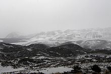
Renewed activity at Parinacota is possible in the future, although the relatively low population density in the region would limit potential damage.
[11] The CVZ has a characteristically thick crust (50–70 kilometres (31–43 mi)) and the volcanic rocks have peculiar oxygen and strontium isotope ratios in comparison to the SVZ and NVZ.
[13] Parinacota lies in a segment of the CVZ where the Peru-Chile Trench undergoes a 45° curvature,[11] and where the direction of subduction changes from diagonal to perpendicular.
[15] A dramatic increment of volcanic activity occurred approximately 27 million years ago, when the Farallon Plate broke apart and subduction increased substantially.
Pyroclastic flows are also found, reaching lengths of 7 kilometres (4.3 mi) and are usually poorly consolidated, containing breadcrust bombs and breccia.
[35] Overall, Parinacota rises 1,800 metres (5,900 ft) from a surface of 170–180 square kilometres (66–69 sq mi); the resulting edifice has a volume of 18–41 cubic kilometres (4.3–9.8 cu mi)[36][6] On the northern side Parinacota partly overlaps with Pomerape,[37] which in turn overlies the rocks of Condoriri farther[18] north; together the volcanoes form a north-northeast trending volcano chain.
[6] Parinacota, Pomerape, and volcanoes farther south like Quisiquisini, Guallatiri and Poquentica constitute the eastern margin of the Lauca basin.
[27] A system of moraines can be seen at an elevation of 4,500 metres (14,800 ft)[39] on the southeastern foot of the volcano, where they partly cross the shores of Lake Chungará.
[43] A retreat of 0.9 square kilometres (0.35 sq mi) was noted between 2002 and 2003,[44] and as of 2007[update] most of the ice lies on the western slope of the mountain.
[8] Parinacota shows evidence of a major sector collapse (a giant landslide),[1] whose deposit was originally interpreted to be a lava flow.
[54] This flow was probably laminar and extremely fast (25–60 metres per second (82–197 ft/s)[26] ), judging from the morphologies of the avalanche deposit,[27] and it incorporated substantial pre-collapse sediments from the Lauca basin.
[62] A few large Toreva blocks lie in the avalanche deposit just at the foot of Parinacota,[8] they reach heights of 250 metres (820 ft) and volumes of 0.05 cubic kilometres (0.012 cu mi).
[64] The avalanche deposit displays a noticeable split into two units; the upper one is andesitic and originated from the actual cone, the lower one is derived from the lava domes beneath the present-day edifice.
[26] This collapse gave birth to Lake Chungará when the avalanche flowed across a westbound drainage between Choquelimpie and Parinacota,[46] forming a 40 metres (130 ft) high volcanic dam that retained about 0.4 cubic kilometres (0.096 cu mi) of water.
[87] A trend to a more tholeiitic composition in younger eruptions may reflect an increased magma flux and a decreased interaction with the upper crust.
[84] In turn, the younger and older Ajata cone lavas have different compositions,[89] one having a high quantity of strontium and the other a low one.
[98] More specifically, after the collapse erupted rocks became more mafic[25] and their composition more influenced by fractional crystallization, while the preceding magmas were more strongly affected by mixing processes.
[104] The area in the crust where such interaction takes place is known as "MASH" or "Melting Assimilation Storage Homogenization", and it is there that the base magmas are formed which then enter into shallow magmatic systems.
[114] The generally arid climate of the region means that volcanoes can remain topographically recognizable for a long time, being subject to only minimal erosion.
[117] Because of the aridity, relatively little sediment is flushed into the Peru-Chile Trench from land, which has effects on the tectonics of the region and the chemistry of the magmas erupted in the volcanoes.
[120] Polylepis tarapacana is the only true tree found at high elevations (up to 5,100 metres (16,700 ft)[119]) and forms small woods.
[118] Among the ecological factors that determine vegetation in the region are lack of water, saline soils, plentiful solar irradiation, herbivores, wind and cold nighttime temperatures.
[31] The "Chungará Andesites" have a volume of over 4 cubic kilometres (0.96 cu mi);[30] material from these stages was incorporated in the collapse deposit.
[31] This and the long delay between the eruption of the Chungará Andesites and the rest of the volcano's history may imply that the magmatic systems involved were different.
[35] Likewise, ash fall deposits found in the Cotacotani lakes have been dated to this period of volcanic history, indicating that the Old Cone occasionally featured explosive eruptions.
[35][134] On the other hand, the younger dates of around 8,000 years ago significantly post-date the end of glaciation, thus if the collapse occurred at that time it was probably unrelated to glacial fluctuations.
[146] The relatively low population density on the Bolivian side of the volcano means that renewed activity would not constitute a major threat there,[147] although the town of Sajama may be affected.
[26] The Arica-La Paz highway runs close to the volcano and might be threatened by mud and debris flows, along with small communities in the area.
The important natural preserve that is the Lauca National Park could suffer significant disruption from renewed eruptions of Parinacota.