Parishes of Grenada
Therefore, a parish has now come to mean an administrative division and is used so by several countries as the smallest unit (or lowest tier) of local government.
Two decades after Barbados was settled the French governor of Martinique, Jacques Dyel du Parquet, purchased Grenada from a French company and in 1650 established a settlement at what was to be Fort Royal in the parish of the low lands (Ville Ft. Royal situé à Paroisse de la Basse Terre).
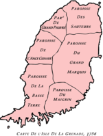
The French cartographer Jacques-Nicolas Bellin (1703–1772) draw several editions of a chart of the island of Grenada showing the earlier French parish divisions and was published as Carte de L'Isle de la Grenade in Paris 1756.
After a century the French capitulated to the British and formally ceded the island to Britain in 1763 by the Treaty of Paris.
The six boundaries or borders of these parishes having already been well established in the mindset of the people then living simply took on the names of these churches.