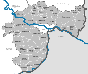
Passau (district)

Neighboring districts are (from the east clockwise) Rottal-Inn, Deggendorf, Freyung-Grafenau.

The district consists of two geographically different parts, separated by the river Danube.

In the north is the southern part of the Bayrischer Wald (Bavarian Forest) mountains with hills up to 1000 meters tall.

The bottom of the coat of arms show the blue-and-white checkered symbol of Bavaria.

The panther is the symbol of the Wittelsbach family, and it represents the area of the former districts Vilshofen and Griesbach.

Deggendorf (district) Rottal-Inn Freyung-Grafenau Passau Witzmannsberg Windorf Wegscheid Vilshofen an der Donau Untergriesbach Tittling Tiefenbach Thyrnau Tettenweis Sonnen Salzweg Ruhstorf an der Rott Ruderting Rotthalmünster Pocking Ortenburg Obernzell Neukirchen vorm Wald Neuhaus am Inn Neuburg am Inn Malching Kößlarn Kirchham Hutthurm Hofkirchen Hauzenberg Haarbach Bad Griesbach Fürstenzell Fürstenstein Eging am See Büchlberg Breitenberg Beutelsbach Bad Füssing Aldersbach Aidenbach Aicha vorm Wald Austria
Clickable map of towns and municipalities in the district
Coat of Arms of Passau district