Patuxent River
Flowing in a generally southeastward direction, the Patuxent crosses the urbanized corridor between Baltimore and Washington, D.C., and opens up into a navigable tidal estuary near the colonial seaport of Queen Anne in Prince George's County, Maryland, just southeast of Bowie.
[7] The Pig Point site includes remnants of the oldest structures ever found in Maryland, wigwam post holes dating to the third century.
[9] The Patuxent River was first named ("Pawtuxunt") on the detailed map resulting from the 1608 voyage upriver by Jamestown, Virginia settler John Smith.
[10] Captain Smith got as far as the rough vicinity of the present-day Merkle Wildlife Sanctuary (Lyons Creek) area, 40 miles (60 km) from the Chesapeake near what is now the Anne Arundel–Calvert–Prince George's County tripoint.
[20][21][22][23] In 1702 George Plater I was the Patuxent naval officer (later based at Sotterley Plantation),[24] having earlier served as Collector after Calvert, Rousby, Sewall, Digges, and Payne held the collectorship.
Calvert and Billingsley Point, two 18th-century mansions 43.5 miles (70 km) upriver from the Chesapeake that are today part of Patuxent River Park.
In August 1814, Commodore Joshua Barney and his Chesapeake Bay Flotilla were trapped in the Patuxent by the British fleet under Admiral Sir George Cockburn.
The Patuxent was plied by regular steamship service, mostly from the Weems Line, from the 1820s to the 1920s, replacing the schooners and sailing packets that had for the previous centuries served the river's many landings and docks along the 52-mile (84 km) tidal reach.
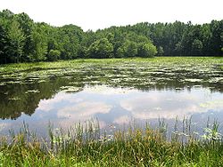
[29] The land surrounding the two reservoirs is administered by the WSSC, creating a forested reserve of 4,400 acres (18 km2) accessible to the public for horseback riding, hunting, fishing, and picnicking in limited areas.
The state of Maryland classifies the T. Howard Duckett Dam as "high hazard" because large releases of water flood areas of North Laurel.
It was the largely unchecked erosion from this late 1960s and 1970s building spree that contributed the bulk of the Patuxent River's highest and most damaging sediment, siltation, and pollution levels to date downstream.
[36] The mission of the Patuxent Riverkeeper organization, a member of the worldwide Waterkeeper Alliance, is to protect and improve the quality of the river's water and watershed and provide access and education at its facility in Nottingham.
[37] Over the past 50 years, nationally recognized land preservation efforts in this part of Maryland have saved tens of thousands of acres from the Baltimore-Washington bedroom community sprawl.
The southern half of the U.S. Army's Fort Meade was added to the Patuxent Wildlife Research Center, which, at 12,300 acres (50 km2), is the second largest contiguous public park-refuge within 30 miles (50 km) of either Washington or Baltimore.
Despite the central role the river has played in the history of the Bay's environmental movement and abundant conservation resources funneled to it over the years, it remains polluted.