Peñalara Cirque
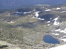
One of them is located in the northeast of the cirque and today houses in its central area the Laguna Grande de Peñalara, and the other is in the southwest and has a less abrupt relief.
Both sectors are separated by a moraine of about 500 meters long that begins at the peak of the Hermana Mayor and extends eastward.
The base of this sector has a higher elevation than the northwest.This cirque was created by glacier action during the Quaternary, approximately 1.8 million years ago, and the most abundant type of surface rock in this area is granite, which is also found in the rest of the Sierra de Guadarrama.
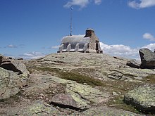
[3] The two glacier lakes, which are of different sizes, are separated by a rocky outcrop on which the Zabala Refuge is located, and which continues in the southern moraine that marks the boundary between the two sectors.
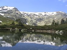
The sector of the Laguna Grande de Peñalara, to the northwest, is more excavated, the lake is deeper, indicating greater ice thickness and erosive capacity.
The streams that run through the cirque, as they pass through the areas with less slope, form several ponds and wetlands during the rainiest seasons of the year, giving rise to aquatic ecosystems.
At the eastern and southeastern end of the cirque there are two glacier lagoons whose existence is temporary because they dry up in the driest summers.
The climate in the circus is alpine, characterized by cold temperatures throughout the year and changing in different seasons, and abundant precipitation, which is snow from mid-November to late April.
This path has a very low level of difficulty, is signposted and is done in an hour and a quarter,[5] which makes the influx of people is abundant throughout the year.
This is one of the reasons why there are areas of the cirque that enjoy a maximum level of environmental protection within the Peñalara Natural Park.
From this road, as it passes through the northeast end of the cirque, there is a path that ascends northwest along the northern moraine and leads to the Laguna de los Pájaros.
The description of a complete circular route to Peñalara and the GPS track can be found on Wikiloc, which also includes references to numerous information, photos and a video that will help the hiker.
There are numerous rock walls in the western part of the circus where it is possible to practice this sport and it represents the cradle of many climbers from Madrid.