Penghu National Scenic Area
Studies about the project were first debated since the beginning of 1990 and, after a year of evaluations carried out by the Tourism Bureau of the Ministry of Transportation and Communications of the Republic of China, it was officially created in February 1991, when the Penghu office was finally established.
But when the autumn gales begin to blow in October, the archipelago becomes deserted until April, when warmer weather seems to thaw the local tourism industry.
Among the tourism routes in Penghu, the natural landscape and ecology of the North Sea islets, fishing villages and water activities are the most popular among tourists.
Tiejhan islet is a classic basaltic hill terrain, and many seabirds come here during the summer to dwell and breed, making this place a spot for bird-watching.
There is a shallow sand belt between Mudou and Jibei, extending hundreds of meters long and 5m wide, where the water only comes up to the knees.
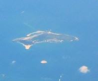
It is a mesa plateau composed by basalt; extending 1 metre from north to south, being the largest unmanned island among the Penghu archipelago.
There is a legend that says that a long time ago, there lived a young lady, who had a boyfriend whom she had loved for years; however, her parents were against this relationship and forced her to marry someone else.
The entire Yuanbei islet is a hill, and it was named so because it is shaped like a seashell covering the water (員貝 means "circular shell").
At the back of the beach is a narrow wooden path built according to the terrain, from there, you can look at Houziwei Cape (鱟仔尾岬) in Chixi (池西) from a distance.
Neian North Sea Fishing Port has been selected by the Penghu County Government to build the first Waterpark in Taiwan.
In front of the Baoan Temple (保安宮) in Tongliang Village (通樑村), there is an old banyan (Ficus benghalensis) dated over 300 years, which is the oldest and largest tree in Penghu, (it occupies a total of 95 cubic feet), which provides shadow for people.
There is a legend about this tree: it says that during 1662–1722, a merchant vessel passed the waters around Tongliang when it encountered a shipwreck, and the only thing that survived was a sapling floating on the sea.
There is an earth mound just north of Shili Village (蒔裡村), shaped like a shamao (紗帽), the hat officials wore in the pre-republican era.
Since Wangan Island houses a harbor with a seabed composed by a mixture of sand beach and mud, in the early days, in addition to coastal fishery and intertidal zone fishing, local residents used to round up catches with a drag net.
In 1949, the fourth mayor of Penghu County, Mr. Liu Yanfu (劉燕夫), agreed to change the official name of the islet to "Cimei" (in Mandarin Chinese it means seven beauties, 七美).
The seventh largest island in Penghu is flat and low in the center, rising up on the east and west, with basaltic transverse joints lined up along the coast.
The other theory says that there must be another reason for it, because the structure is documented in historical literature, and not only is in the ancient history books, but also in many local legends that name this unusual sight.
In 1944, during the Second World War, the Imperial Japanese Army forced the residents of Wangan and Zangjun islands to dig this cave to store gunpowder and weapons.
In 1994, the first green turtle carrying a satellite tracker set out from Wangan in Penghu, heading North crossed the Taiwan Strait, through the East China Sea Shelf, ending up in an island south of Kyūshū in Japan.
Many beaches on the island of Taiwan were recorded to have sea turtles coming ashore to lay eggs, but as development changed the coastal environment, fewer places were able to support natural life.
Originally named "Flower House" (花宅), the legend says that when this village was firstly established, their ancestors looked at the local terrain, and discovered that the mountains surrounding the place were just like lotus petals.
There are a total of 558 stone weirs in Penghu, and up to 88 of them are distributed around Jibei islet, ranking first in the world both in terms of number and density.
Situated 500 meters southeast of Nanhu Port in Cimei Township, the Seven Beauties Tomb (Chinese: 七美人塚) is what remains of a well-known story of chastity.
The place is called this way because looking down from a gazebo, visitors can see the result of years of wave erosion, forming an abrasion platform shaped like the island of Taiwan on a reduced scale, hence, it is called Cimei Little Taiwan (七美小台灣); there is also a rock shaped like Gueishan Island (龜山島) in the same spot: both structures look even more obvious when the tide is low.
Also located in Cimei, the Great Lion Scenic Area (Chinese: 大獅風景區) overlooks Longcheng (龍埕, "shaped like a dragon").
However, the Scenic Area is mostly visited during the summer: when the autumn gales begin to blow in October, the archipelago becomes deserted until April, when warmer weather seems to thaw the local tourism industry.
[4] Generations of Penghu residents have made their living from the sea, but over-fishing has severely depleted stocks and damaged the local fishing industry.
[4] Several projects aimed at attracting tourists in winter have been tried with only limited success: During July 2003, the Public Construction Commission and the Penghu National Scenic Area Administration under the Ministry of Transportation and Communication's Tourism Bureau agreed a development project in Jibei Islet (吉貝嶼): the more than NT$ 300 million investment would turn 22 hectares of land and 210 hectares of surrounding sea into an international recreational tourist spot.
[8] This project soon met with strong opposition from local green activists: "What we see here is a solution for an unsatisfactory situation that actually makes things worse," Chen Yufeng (陳玉峰), an ecologist, said.
[5] To promote the Scenic Area, the local government hosted swimming events, fireworks displays and parades of elaborately decorated vehicles.