Penrith, Cumbria
[M 1] The Neolithic (c. 4500–2350 BCE) or early-Bronze Age (c. 2500–1000 BCE) sites at nearby Mayburgh Henge, King Arthur's Round Table, Little Round Table, Long Meg and Her Daughters, and Little Meg, and the stone circles at Leacet Hill and Oddendale are some of the visible traces of "one of the most important groups of prehistoric ritual sites in the region."
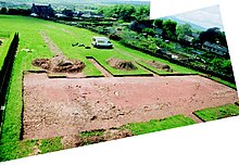
[M 2] For the Celtic (Iron Age) era (c. 800 BCE – 100 CE), nearby Clifton Dykes has been proposed as the centre of the Carvetti tribe, due to the large enclosure discovered there and assumptions about the strategic position of the Penrith area in the communications systems running north–south through the Eden Valley and east–west across Stainmore.
[11] The 18th-century antiquarian and vicar of Penrith, Dr.Hugh Todd, speculated that the Ala I Petriana may have been stationed there, giving its name to the subsequent town,[M 4] but see the "Toponymy" section above.
It also gained growth from its proximity to the Inglewood Forest and to the fertile Eden valley, and largely depended upon agriculture, especially cattle rearing and droving.
The Celtic place-names in the region such as Penrith, Blencow, Culgaith, Penruddock, were now joined by settlements ending in "-ham" (estate) and "-ton" (farm), such as Askham, Barton, Clifton, Plumpton and Stainton.
Settlements with names ending in "-by" ("village") and "-thorpe" ("hamlet") were largely on higher ground – the Vikings were pastoralists, the Angles arable farmers.
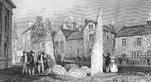
They appear to be an Anglo-Norse fusion of Christian and Norse motifs, but it is still debated whether they are linked to the King of the Strathclyde Cumbrians, Owain ap Dyfnwal (fl.
[M 9] On 12 July 927, Eamont Bridge (or possibly the monastery at Dacre, Cumbria, or the site of the old Roman fort at Brougham or even the church at Penrith, or a combination of these) was the scene of a gathering of kings from throughout Britain as recorded in the Anglo-Saxon Chronicle and the histories of William of Malmesbury and John of Worcester.
This was strengthened in 1391 by the townspeople and Penrith's patron, William Strickland, Bishop of Carlisle, after another Scottish raid by the 1st Earl of Douglas in 1380, and others in 1383 and 1388, when Brougham Castle was probably destroyed as well.
[M 20] Strickland shared power in Penrith with the Neville family, which had been promoted in the North by Richard II of England to offset the influence of the Percies.
The English Reformation, economic and social progress, educational change, the rise of the non-noble landed gentry and the depredations of the plague all affected Tudor England, and Penrith was no exception.
[M 22] The eclipse of the Nevilles and Percies by the end of the Wars of the Roses opened the field for families such as the Cliffords, the Dacres and the Musgraves to jostle for position in the North (including those of the Sheriff of Cumberland, the Warden of the West March and the keeper of Penrith Castle).
The merchant, Robert Bartram, may have built the Tudor House in St Andrew's Place (1563), indicating a trading class operating in Penrith.
[M 25]However, there may have been a substantial underclass as well, as shown by possible poverty and poor nutrition causing a high death rate in 1587, when there may have been a typhus epidemic.
[M 26] Penrith in Stuart times was affected by political and religious upheavals that saw the English Civil War, the Commonwealth and the Glorious Revolution, but was spared any fighting.
Major-General Lambert, the Parliamentary commander, took over Penrith in June 1648 until forced out by Scottish royalists aided by Sir Philip Musgrave of Edenhall.
During the Commonwealth, Presbyterian "Godly rule" was administered at St Andrew's Church by the local Justice of the peace, Thomas Langhorne, who had bought Lowther's Newhall/Two Lions house.
He was attempting to gauge the views of leading figures in the counties (deputy-lieutenants, and J.P.s) on the intention of King James II to introduce greater religious toleration.
It was one of seven constablewicks into which the ancient Penrith parish divided, alongside Middlegate, Burrowgate, Dockray and Netherend in the town proper and Plumpton Head and Carleton beyond.
There are also areas that still have farming names, such as a wooded enclosure in Fell Lane known as the Pinfold (or Pinny) – once a pound for stray animals until owners paid to reclaim them.
The Wetheriggs, Skirsgill and Castle Hill or Tyne Close areas were developed in the 1920s by Penrith Urban District Council on land formerly known as Scumscaw.
Penrith Hospital and Health Centre lies along Bridge Lane at the southern entrance to the town, close to the Kemplay Bank roundabout, where the A6, A66 and A686 meet.
Various weekly clinics are held at the hospital and the adjacent health centre, which opened in 1983 and brought all three NHS medical practices into one building – two have since merged.
The Great North Air Ambulance Service has its Cumbrian base close to Penrith at Langwathby and was at one time-based at Carleton Hall.
Amateur dramatics and musicals are staged at the Penrith Players Theatre, Ullswater Community College and Queen Elizabeth Grammar School.
As a market town relying heavily on the tourist trade, Penrith benefits from some high-street chain stores and local specialist shops alongside other businesses such as banks, building societies and travel agents.
The model firm Lilliput Lane (now part of Enesco) was founded in Penrith and until March 2009 had its main factory at Skirsgill Park.
Local butchers Cranstons have an expanding meat packing, pie and sandwich-manufacturing site alongside their shop and head office on Ullswater Road.
[42] They cater for junior players from the age of 11, as well as adults, playing at both secondary schools (QEGS and Ullswater Community College) in the town.
Its main activity is canoe polo, in which the club was represented at the World Championships in Syracuse, Italy 2016 by its under-21 women's squad, which finished a respectable fourth.