Perea
Perea or Peraea (Greek: Περαία, "the country beyond") was the term used mainly during the early Roman period for part of ancient Transjordan.
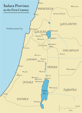
Josephus notes that Perea's northern boundary was near Pella, while to the east, it bordered the territories of Gerasa and Philadelphia (both part of the Decapolis) and Heshbon.
Josephus depicted Perea mainly as "desert" and "rugged," with pockets of well-cultivated areas, a feature now undergoing transformation due to extensive irrigation initiatives.
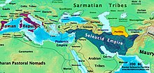
[2] The territory of what would at one point in history become known as Peraea or Perea was part of Trans-Jordan, which in the Hellenistic period changed hands between the states of the heirs of Alexander the Great, the Nabataean Arabs, and the Jewish Hasmoneans.
[10][11] Following the Roman conquest of Judea led by Pompey in 63 BCE, Aulus Gabinius, proconsul of Syria, split the former Hasmonean kingdom into five districts of legal and religious councils known as synedria (in Jewish context better known as sanhedrins) and based at Jerusalem, Jericho, Sepphoris (Galilee), Amathus (Perea) and Gadara (either in Perea at Al-Salt, in the Decapolis at Umm Qais,[12][13][14][15][16] or at biblical Gezer in Judea, mentioned by Josephus under a Hellenised form of its Semitic name, Gadara, edited to "Gazara" in the Loeb edition[17]).
Peraea is covered with rugged mountains, and is separated from the other parts of Judaea by the river Jordan (in the original Latin: "Supra Idumaeam et Samariam Iudaea longe lateque funditur.
Pars eius Syriae iuncta Galilaea vocatur, Arabiae vero et Aegypto proxima Peraea, asperis dispersa montibus et a ceteris Iudaeis Iordane amne discreta.
The land of Moab forms its southern limit ; while Arabia and Silbonitis, with Philadelphia and Gerasa, constitute its eastern boundary.