Petra
Petra (Arabic: ٱلْبَتْراء, romanized: Al-Batrāʾ; Ancient Greek: Πέτρα, "Rock"), originally known to its inhabitants as Raqmu (Nabataean: 𐢛𐢚𐢒 or 𐢛𐢚𐢓𐢈, *Raqēmō),[3][4] is a historic and archaeological city in southern Jordan.
Petra flourished in the 1st century AD, when its Al-Khazneh structure, possibly the mausoleum of Nabataean king Aretas IV, was constructed, and its population peaked at an estimated 20,000 inhabitants.
By the early Islamic period, it was largely abandoned, except for a handful of nomads, and it remained unknown to the western world until 1812, when Swiss traveller Johann Ludwig Burckhardt rediscovered it.
[17] The Edomite site excavated at the top of the Umm el-Biyara mountain at Petra was established no earlier than the seventh century BC (Iron II).
[22] Arabic raqama means "to mark, to decorate", so Rekeme could be a Nabataean word referring to the famous carved rock façades.
In 125 AD, one of Emperor Hadrian's administrators left marks[dubious – discuss] in Petra, pointed out by documents found at the Dead Sea.
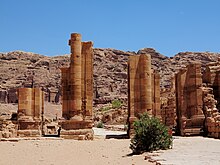
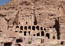
The province's governor, Sextius Florentinus, erected a monumental mausoleum for his son near the end of the al-Hubta (King's Wall) tombs, which had been generally reserved during the Nabataean period for the royal family.
The interest that Roman emperors showed in the city in the 3rd century suggests that Petra and its environs remained highly esteemed for a long time.
It is the castle that was seized by a band of Turks with the help of local Muslims and only recovered by the Crusaders after they began to destroy the olive trees of Wadi Musa.
The ruins of Petra were an object of curiosity during the Middle Ages and were visited by Baibars, one of the first Mamluk sultans of Egypt, towards the end of the 13th century.
[37] The Scottish painter David Roberts visited Petra in 1839 and returned to Britain with sketches and stories of the encounter with local tribes, published in The Holy Land, Syria, Idumea, Arabia, Egypt, and Nubia.
In 1929, a four-person team consisting of British archaeologists Agnes Conway and George Horsfield, Palestinian physician and folklore expert Tawfiq Canaan and Ditlef Nielsen, a Danish scholar, excavated and surveyed Petra.
Hammond believed the carved channels deep within the walls and ground were made from ceramic pipes that once fed water for the city, from rock-cut systems on the canyon rim.
[39] In the 1980s, the Bedul Bedouin, once inhabitants of Petra, were relocated by the Jordanian government to the nearby settlement of Umm Sayhoun, a process spanning two decades.
[40][41] With a name meaning "the changing ones" and oral traditions recounting a conversion narrative, the Bedul Bedouins are believed to have adopted Islam later in their history, possibly with Jewish or Nabatean origins.
[40] Numerous scrolls in Greek and dating to the Byzantine period were discovered in an excavated church near the Temple of the Winged Lions in Petra in December 1993.
[25] Excavations have demonstrated that it was the ability of the Nabataeans to control the water supply that led to the rise of the desert city, creating an artificial oasis.
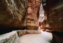
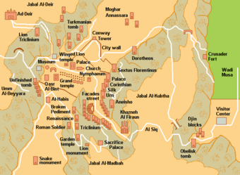
The impressive eastern entrance leads steeply down through a dark, narrow gorge, in places only 3–4 m (10–13 ft) wide, called the Siq ("shaft"), a natural geological feature formed from a deep split in the sandstone rocks and serving as a waterway flowing into Wadi Musa.
At the end of the narrow gorge, the Siq, stands Petra's most elaborate ruin, popularly known as Al-Khazneh ("the Treasury"), hewn into the sandstone cliff.
While remaining in remarkably preserved condition, the face of the structure is marked by hundreds of bullet holes made by the local Bedouin tribes that hoped to dislodge riches that were once rumoured to be hidden within it.
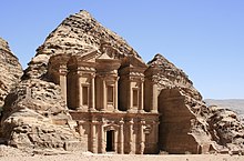
[49] A little farther from the Treasury, at the foot of the mountain called en-Nejr, is a massive theatre, positioned so as to bring the greatest number of tombs within view.
Almost enclosing it on three sides are rose-coloured mountain walls, divided into groups by deep fissures and lined with knobs cut from the rock in the form of towers.
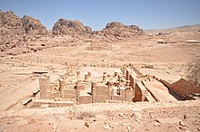
Originally said to be a market area,[53] excavations at the site have allowed scholars to identify it as an elaborate Nabataean garden, which included a large swimming pool, an island-pavilion, and an intricate hydraulic system.
[60] In 2016, archaeologists using satellite imagery and drones discovered a very large, previously unknown monumental structure whose beginnings were tentatively dated to about 150 BC, the time when the Nabataeans initiated their public building programme.
Enclosed by towering rocks and watered by a perennial stream, Petra not only possessed the advantages of a fortress, but controlled the main commercial routes which passed through it to Gaza in the west, to Bosra and Damascus in the north, to Aqaba and Leuce Come on the Red Sea, and across the desert to the Persian Gulf.
New evidence indicates that broader Edomite, and Nabataean theology had strong links to Earth-Sun relationships, often manifested in the orientation of prominent Petra structures to equinox and solstice sunrises and sunsets.
The stele is horned and the seal from the Edomite Tawilan near Petra identified with Kaush displays a star and crescent (Browning 28), both consistent with a moon deity.
The village of Wadi Musa is the largest in the area, inhabited largely by the Layathnah Bedouin, and is now the closest settlement to the visitor centre, the main entrance via the Siq and the archaeological site generally.
This is intended to guide planned development of the Petra Region in an efficient, balanced and sustainable way over the next 20 years for the benefit of the local population and of Jordan in general.
[74] The process of developing the Strategic Plan considered the area's needs from five points of view: The site suffers from a host of threats, including collapse of ancient structures, erosion due to flooding and improper rainwater drainage, weathering from salt upwelling,[75] improper restoration of ancient structures, and unsustainable tourism.