Point Reyes National Seashore
Clem Miller, a US Congressman from Marin County, wrote and introduced the bill for the establishment of Point Reyes National Seashore in 1962 to protect the peninsula from development which was proposed at the time for the slopes above Drake's Bay.
The Point Reyes peninsula is a well defined area, geologically separated from the rest of Marin County and almost all of the continental United States by a rift zone of the San Andreas Fault,[5] about half of which is sunk below sea level and forms Tomales Bay.
The small town of Olema, about 3 miles (4.8 km) south of Point Reyes Station, serves as the gateway to the Seashore and its visitor center.
[6] Other parts are under the jurisdiction of other conservation authorities with the National Park Service providing signage and managing visitor impact on the entire peninsula and Tomales Bay.
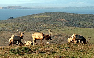
Until recently, the northernmost part of the peninsula, Tomales Point, was maintained as a reserve for tule elk (Cervus canadensis nannodes), a species historically native to the region.
[13] The Park Service began a public review and comment period in 2023 on a proposal remove of the tule elk fence with a final decision expected in the summer of 2024.
Then, in January, 2025 a deal brokered by The Nature Conservancy led to a buy-out of most of the peninsula's ranchers, reducing the number of cattle from about 10,000 to 200 over the next 1.5 years, and returning most of the park to wilderness status.
[16] The Point Reyes Lighthouse attracts whale-watchers looking for the gray whale migrating south in mid-January and north in mid-March.
When Elephant seals (Mirounga angustirostris) established a rookery in 1981, Point Reyes National Seashore became the only park in the world with breeding ungulates and pinnipeds.
The first elephant seal breeding colony was established at Chimney Beach, which is protected by 100-foot (30 m) cliffs,[17] although the first documented pup was born at Point Reyes in 1976.
[24] It has yellow flowers that bloom from March through May, grows in plant communities of coastal scrub, and is extremely poisonous (major toxicity class 1 [25]).
In his book The Natural History of the Point Reyes Peninsula, Jules Evens identifies several plant communities.
One of the most prominent is the Coastal Douglas-fir (Pseudotsuga menziesii) forest, which includes Coast live oak, Tanoak, and California bay and reaches across the southern half of Inverness Ridge toward Bolinas Lagoon.
The Coast Miwok people who once lived in the area set frequent fires to clear brush and increase game animal populations, and early explorers' accounts describe the hills as bare and grassy.
[29] Extremely high levels of fecal coliform bacteria (Escherichia coli) concentrations have been documented in streams adjacent to existing dairy operations.
Tomales Bay, Drakes Estero and Abbotts Lagoon are all affected by E. coli discharges from cattle operations in rainy winter months.
[34] After the descendants of the Felix family left in 1955, the land was zoned for development, then made part of the Point Reyes National Seashore, before becoming home to artist Clayton Lewis.
[38] More than 30,000 acres (120 km2) of the Point Reyes National Seashore are designated as the Phillip Burton Wilderness, named in honor of California Congressman Phillip Burton, who wrote the legislation creating the Golden Gate National Recreation Area and was instrumental in helping to pass the California Wilderness Act of 1984.
Within this area are forests of Douglas fir and California buckeye, coastal foothills, terraces, caves, beaches, several small inland lakes and the high point of Mount Wittenberg.
It travels mostly streamside through a shaded, fern-laden canyon, breaking out at Divide Meadow before heading downward to the coast, where it emerges at Arch Rock.
The trail provides descriptions of the fault and the surrounding geology, and features a fence that was pulled 18 feet (5.5 m) apart during the 1906 San Francisco earthquake.
Ocean vistas from higher ground can be seen from the Tomales Point Trail and, to the south, from the Palomarin trailhead at the park's southern entrance outside the town of Bolinas.
[43] The farm was purchased by the National Park Service in 1972, and the agency issued a permit to allow the previous owner to continue operations for 40 years.
The business was sold to a new owner in 2004, the Drakes Bay Oyster Company, who was informed by the NPS at the time of purchase that their permit to operate would not be renewed beyond the November 30, 2012 expiration date.
[45] The NPS and conservation groups viewed the farm as an inappropriate and environmentally-insensitive use of the estero, which was designated a "potential wilderness area" by Congress.
[48] The challenge was rejected by a federal court judge, who ruled that the law gave Salazar unfettered discretion to approve or deny a renewal of the permit.