Phoenix metropolitan area
This also contributed to the entire state's exceptional growth; the area is home to just over two-thirds of Arizona's population.
The population of the Phoenix metropolitan area increased by 45.3% from 1990 through 2000, compared to the overall U.S. rate of 13.2%, helping make Arizona the second-fastest growing state in the nation in the 1990s behind Nevada.
Water insecurity and drought in conjunction with climate change have become a significant concern for the metropolitan area's future growth prospects.
[7] The Phoenix–Mesa combined statistical area (CSA) was designated in September 2018 by U.S. Office of Management and Budget (OMB) and by the Census Bureau which consists of the entirety of the counties of Maricopa, Pinal, and Gila.
The MSA is one of the sunniest major metropolitan areas, receiving 295 days of sunshine, compared to the national average of 205.
As with the state of Arizona, the area relied on the 5 C's (copper, cattle, climate, citrus, and cotton) for its economic growth and expansion.
About 10 million people visit from other states and Canada each year, due to the area's mild winters and long, sunny days.
Other Fortune 500 companies with significant presence include Banner Health, the state's largest private employer, American Airlines, which merged with Tempe-based US Airways, American Express, Wells Fargo, Boeing, and Intel, which has a large regional campus in Chandler.
[30] The Metropolitan Area ranks 5th in the nation in economic growth, which is a major comeback from the recession.
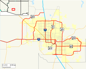
Most of the arterial roads in the Phoenix metropolitan area are laid out on a regular grid, following the section lines established in the Public Land Survey System.
As a result, arterial roads in cities that had once been geographically separate may have been given different names while occupying the same section line.
Broadway Road, for example, starts and stops multiple times, passing through Goodyear, Avondale, Phoenix, Tempe, Mesa, and Apache Junction, each with their own reference point for address numbering.
[34][35] Most communities in Maricopa County use the Phoenix-County numbering system, with the point of origin at Central Avenue and Washington Street.
[41] Numerous trailer parks inside the city limits run their own contradictory variations of the numbered street system.
[43] In terms of safety, the Phoenix–Mesa–Chandler, AZ metropolitan area has been ranked 16th most dangerous in the USA, based on its Pedestrian Danger Index, computed on the share of local commuters who walk to work and the most recent data on pedestrian deaths as found in a 2016 report released by Smart Growth America.
Amtrak also provides additional Thruway Motorcoach service from Phoenix Sky Harbor International Airport to Flagstaff station, which is served by the Southwest Chief.
Amtrak's Los Angeles-New Orleans Sunset Limited served the city of Phoenix directly from 1971 until it was rerouted on June 2, 1996, to a more southerly route between Tucson and Yuma, Arizona, in order to accommodate the Union Pacific Railroad's desire to abandon a portion of its Phoenix-to-Yuma "West Line."
A light rail system (dubbed the "METRO Light Rail") runs more than 20 miles from suburban Mesa, through Tempe and into Phoenix, traveling through the downtown area, offering access to Phoenix Sky Harbor International Airport and linking two of the four metro area campuses of Arizona State University.
[47] With two active terminal buildings encompassing 117 gates, more than 25 airlines offer daily non-stop flights to destinations throughout the world.