Pictured Rocks National Lakeshore
The park has extensive views of the hilly shoreline between Munising and Grand Marais in Alger County, with picturesque rock formations, waterfalls, and sand dunes.
[3] Although the Pictured Rocks shore waters are a rich fishing ground, the sandstone cliffs are dangerous to canoes and other open boats skirting the coastline.
Geologist and US Indian Agent Henry Rowe Schoolcraft visited in 1820 and remarked upon "some of the most sublime and commanding views in nature".
[4] In 1850, George Copway Kah-Ge-Ga-Gah-Bow, a Mississaugas Ojibwe writer and Methodist missionary, published The Traditional History and Characteristic Sketches of the Ojibway Nation, in which he cited the detailed description of the Pictured Rock by General Lewis Cass.
[5]: 24–7 Around 1850, developers planned a tourist resort, Grand Island City, adjacent to the Pictured Rocks near the current site of Munising.
After the lumbering era ended around 1910, much of the land making up the current National Lakeshore reverted to the state of Michigan for unpaid property taxes.
In October 1966, Congress passed a bill authorizing the establishment of the Pictured Rocks National Lakeshore " to preserve for the benefit, inspiration, education, recreational use, and enjoyment of the public, a significant portion of the diminishing shoreline of the United States and its related geographic and scientific features.
Miners Castle consists of crumbly cross-bedded sandstone poorly cemented by secondary quartz, according to Research Ecologist Walter Loope of the U.S. Geological Survey.
On March 30, 2009, the Omnibus Public Land Management Act was signed into law, protecting 11,740 acres (47.5 km2) of Pictured Rocks as the Beaver Basin Wilderness, spanning the 13 miles of shoreline.
[12] Features include: From the west (Munising) to the east (Grand Marais): Pictured Rocks is the site of many of Michigan's waterfalls.
Sand washed ashore by wave action was then blown upslope by northerly prevailing winds until it came to rest atop a glacial moraine.
Glacial melt during the last major advance/retreat called the Marquette Readvance created the conditions for the formation of the Grand Sable Banks.
The Grand Sable Dunes perched on top of these banks offers a desolate sandscape with jack pine forest near the edges.
[20] Pictured Rocks National Lakeshore is a popular scuba diving destination in the Midwest and country, as the turbulent waters of Lake Superior have created many shipwrecks to explore over the years.
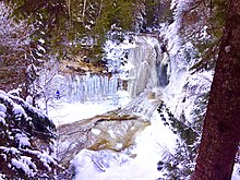
Additionally, the long winter and constant runoff from snowmelt create one of the best ice-climbing opportunities in the country, with over 50 named ice formations.