Pirin National Park
Pirin National Park (Bulgarian: Национален парк "Пирин"), originally named Vihren National Park, covering the larger part of the Pirin Mountains in southwestern Bulgaria, spanning an area of 403.56 square kilometers (155.82 sq mi).
The park is situated in Blagoevgrad Province, the nation's southwesternmost region, on the territory of seven municipalities: Bansko, Gotse Delchev, Kresna, Razlog, Sandanski, Simitli, and Strumyani.
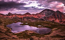
There are also a few small glaciers, such Snezhnika, located in the deep Golemiya Kazan cirque at the steep northern foot of Vihren, and Banski Suhodol.
Pirin National Park was established on 18 November 1962 in order to preserve the natural ecosystems and landscapes along with their plant and animal communities and habitats.
[3][4] In 1983, Pirin National Park was added to the list of UNESCO World Heritage Sites as an area of outstanding natural importance.
The entire territory of the park is included in the European Union network of nature protection areas Natura 2000.
[7] Pirin National Park is listed as an important bird and biodiversity area by BirdLife International.
[8] Pirin National Park is managed by a directorate subordinated to the Ministry of Environment and Water of Bulgaria based in the town of Bansko at the northern foothills of the mountain.
[18] Pirin National Park encompasses much of the homonymous mountain range in southwestern Bulgaria, which forms part of the Rila–Rhodope Massif.
The modern relief of Pirin was shaped in the Pleistocene (2,588,000 to 11,700 years ago) when the mountain was subjected to alpine glaciation related to the global cooling.
[22] The limits of the glaciers reached 2200–2300 m. All glacial forms in the mountain range are within the borders of Pirin National Park.
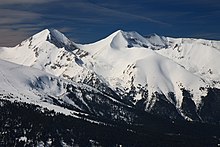
[20][23] The southern zone consists of granite ridges and includes Pirin's fourth highest summit Polezhan, at 2851 m.[24] There are more around 60 summits above 2600 m.[22] The relief of Pirin National Park is alpine and highly fragmented and is characterized with steep slopes, high ridges and deep river valleys.
[26] Geologically Pirin is a massive anticline formed by metamorphic rocks — gneiss, biotite and crystalline schists, amphibolite, quartzite and marble.
[27][28] Paleozoic granitoid rocks are found in restricted areas in the outskirts of Pirin National Park.
The Central Pirin pluton covers the southern reaches of the park and is dated to the Upper Oligocene.
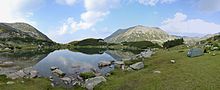
[32] The territory of Pirin National Park is almost equally divided between the basins of the rivers Struma (206.06 km2 or 51.1%) and Mesta (197.50 km2 or 48.9%).
Snezhnika is located in the deep Golemiya Kazan cirque at the steep northern foot of Vihren and is the southernmost glacier in Europe.
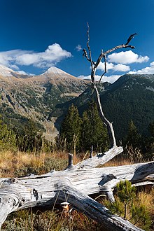
[39] The Macedonian and the Bosnian pines in Pirin National Park constitute respectively 42% and 52% of their total area in Bulgaria.
[41] The varied relief creates various ecological environments for plants, further diversified by the dominant rock types which form siliceous and calcareous terrain on the territory of the park.
[44] The vascular plants in Pirin National Park include 1315 species of 94 families and 484 genera, or approximately 1/3 of Bulgaria's flora.
[43] The number of vascular plant species is expected to grow in case of future detailed research, especially at lower elevations.
[60] They are poorly researched and there is not enough data to assess the qualitative and quantitative parameters even of the main populations of endemic and relict species.
[62] Some of the most spectacular butterflies are the mountain Apollo (Parnassius apollo), clouded Apollo (Parnassius mnemosyne), false Eros blue (Polyommatus eroides), mountain Alcon blue (Phengaris rebeli), large blue (Phengaris arion), scarce tortoiseshell (Nymphalis xanthomelas), Titania's fritillary (Boloria titania), eastern large heath (Coenonympha rhodopensis), Cynthia's fritillary (Euphydryas cynthia), etc.
[63] As of 2002 on the territory of the park there were 1837 beds, including 885 in mountain refuges, 214 in hotels, 124 in bungalows and 615 in premises belonging to different departments of the state administration.
[64] Some of the refuges include Bezbog, the largest and most modern one; Banderitsa, constructed in 1915 by order of Tsar Ferdinand I of Bulgaria, and Vihren.
[63][65] The most challenging hiking trail follows the top of the Koncheto ridge at an elevations of approximately 2,810 m, between the peaks Banski Suhodol (2,884 m) and Kutelo (2,908 m).
Rock quarries, wildland arson, industrial and illegal logging, poaching, excessive trail use, vehicle access, and most notably the ski resorts have put the park under significant threat.
There has been a steady development of skiing infrastructure since the early nineties along the northeast of the range, most notably in the town of Bansko, which has become an international winter resort.
In 2003, a large forested portion of the Todorka peak and the nearby ridges were cleared to begin the construction of the resort which today has 13 ski lifts and 75 km of slopes.
[68] In November 2017, the World Wide Fund for Nature and other local NGOs filed a lawsuit against the Bulgarian Ministry of the Environment and Water as they deemed that plans for development of the area violated environmental regulations.