Pit River
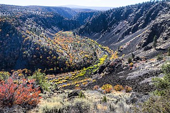
[7][8] The Pit River drains a sparsely populated volcanic highlands area in Modoc County's Warner Mountains, passing through the south end of the Cascade Range in a deep canyon northeast of Redding.
[11][12] Although Goose Lake is generally considered the terminal sink of an endorheic basin, it will overflow into the Pit River during floods; however this has not occurred since 1881 due to large diversions of water for agriculture.
It then turns south to join the Sacramento River as the eastern arm of Shasta Lake reservoir, approximately 15 miles (24 km) north of Redding.
The upper reaches of the Pit above Fall River Mills are a snow-fed high desert stream with a much more seasonal hydrograph.
[12] The lowermost part (Shasta Lake portion) of the Pit River system receives heavy winter rainfall, which mainly contributes to streamflow between November and April.
[17] The aquifers in the Pit River basin may hold as much as 16 million acre-feet (20 km3) in storage and are consistently replenished by winter precipitation seeping through the watershed's porous volcanic rocks and soils.
[18] The water typically emerges at points of lower elevation where the surface layers encounter harder metamorphic and sedimentary rock.
A short minimum flow of 30 cu ft/s (0.85 m3/s) occurred on July 12, 1975 due to construction work at Pit 7 Powerhouse requiring temporary cessation of releases.
Because of the dependable flow, large reservoirs are not needed to regulate releases for power generation, unlike other major hydroelectric schemes in California.
PG&E is now required to maintain base flow in the river at all times, which has led to a reduction in hydroelectric power generation but has greatly improved wildlife habitat and fishing on these sections of the Pit.
[41][42] The Pit River is located in historical Achomawi territory, who lived in the area expanding from Big Bend to Goose Lake.
Achomawi moved between hunting camps in summer, consisting of cone-shaped tents covered with tule, and larger wood-frame pit houses in winter.
Achomawi territory was bordered by that of the Klamath and Modoc to the north, the Shasta to the northwest, the Wintun on the west (in the lower Pit and McCloud River valleys), the Yana on the southwest, Maidu to the south, and Paiute to the east.
Most of the local tribes have had social and border disputes since ancient times; the Achomawi and Atsugewi were historically subject to raids by the Klamath and the Modoc who would take prisoners to sell as slaves at The Dalles, Oregon – then a major Native American trading hub on the Columbia River, more than 300 miles (480 km) to the north.
[43] In the early 1800s, armed with horses and firearms obtained by trading with Europeans, the Paiute launched a full-scale attack on the Achomawi, with one raid killing between 200 and 300 people in a camp near modern Fall River Mills.
Despite multiple attempts by leaders on both sides to make peace, "each time the truce was soon broken by irresponsible young fellows whom the chiefs could not control.
"[45] Native peoples also grew hostile towards Euro-American settlers and traders, who entered the region in great numbers beginning in the mid-19th century, especially during and after the California Gold Rush in 1848.
In retaliation, a band of white men attacked a native camp at Beaver Creek (near present-day Pittville) killing 160 people, mostly women and children.
[48] Due to the arid climate, poor soils and rugged topography of the Pit River basin and northeastern California in general, settlement and development of the region was difficult.
[12] Due to limited and uncertain streamflow from these snowfed desert streams, the amount of farmland in the Pit River system remained small, and water rights were a contentious issue.
About one-quarter of the river's flow would be diverted to irrigate some 60,000 acres (24,000 ha) of fertile benchland in the upper Sacramento Valley, east of Redding.
Shasta Lake raised the level of the Pit River more than 100 feet (30 m) above the elevation of the proposed Sheep Rocks dam.
The river is notorious for its swift, deep water, slippery bed and low visibility, and is considered difficult and dangerous to wade.
Flows are fairly consistent year-round, except after storm events, both due to the natural springs feeding the river and regulation by many hydroelectric dams.


