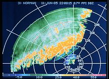
Plan position indicator
The PPI display was first used prior to the start of the Second World War in a Jagdschloss experimental radar system outside Berlin.
The first production PPI was devised at the Telecommunications Research Establishment, UK and was first introduced in the H2S radar blind-bombing system of World War II.
Originally, data was displayed in real time on a cathode-ray tube (CRT), and thus the only way to store the information received was by taking a photograph of the screen.
Philo Taylor Farnsworth, the American inventor of all-electronic television in September 1927, contributed[citation needed] to this in an important way.
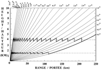
In meteorology, a competing display system is the CAPPI (Constant Altitude Plan Position Indicator) when a multi-angle scan is available.