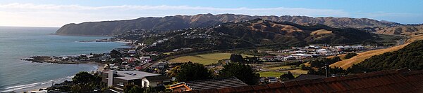
Plimmerton
[3] In the 1840s the area where Plimmerton is situated was the home of Te Rauparaha, who had his main residence at Taupō pā.
Te Rauparaha was captured by 200 British troops and police on 23 July 1846 near the southern end of Motuhara Road.
In 1847, most of Ngāti Toa’s land in Porirua was sold to the Crown for the New Zealand Company by a group of eight chiefs, and Taupō was retained as part of a Māori reserve (one of three) that extended from Paremata to Paekākāriki.
[4] However, the following year Te Rauparaha was released and retired to Ōtaki; by 1850 Taupō pā was deserted.
[5][6] The area continued to be referred to as Taupō, after the pā, and was leased by Ngāti Toa for farming by European settlers over the following decades.
[4] When the Horokiwi Valley Road was opened fewer travellers followed the Taua Tapu track through Taupō to Pukerua Bay.
Several towns, including Plimmerton, were established along the way to encourage settlements that would contribute to the line's business.
In 1885 the first excursion train journeyed from Wellington to Plimmerton on 3 September, and regular services began from 10 October.
Plimmerton House, a two-storied hotel, was built alongside the railway station in 1886 (and burnt down in 1907).
[11] It excludes the largely Māori (Ngāti Toa) settlement of Hongoeka to the west, which was gazetted on 16 December 2010.
[14] State Highway 59, here named St Andrews Road, passes through Plimmerton, as does the North Island Main Trunk railway line A shopping area about two blocks long adjoins Plimmerton Railway Station on Steyne Avenue and includes a church, a medical centre, Plunket rooms, a craft shop, a beauty salon, real estate agents, a grocery store and several eateries.
Recreational water quality at Plimmerton Beach is rated "fair" by the Greater Wellington Regional Council; water quality at South Beach is rated "poor", however, due to periodic faecal contamination.
[20] Another popular beach is Karehana Bay, at the foot of the Airlie Road/Cluny Road valley about 1.5 kilometres north-west of the shops.