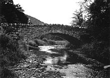
Plunketts Creek Bridge No. 3
3 was considered "significant as an intact example of mid-19th century stone arch bridge construction",[2] and was added to the National Register of Historic Places (NRHP) on June 22, 1988.
Later that year, a replacement bridge was built and the old stone structure was documented by the Historic American Engineering Record.
Plunketts Creek is in the West Branch Susquehanna River drainage basin, the earliest recorded inhabitants of which were the Susquehannocks.
Their numbers were greatly reduced by disease and warfare with the Five Nations of the Iroquois, and by 1675 they had died out, moved away, or been assimilated into other tribes.
The West Branch Susquehanna River valley was subsequently under the nominal control of the Iroquois,[3] who invited displaced tribes, including the Lenape (Delaware) and Shawnee to live in the lands vacated by the Susquehannocks.
The French and Indian War (1754–1763) led to the migration of many Native Americans westward to the Ohio River basin.
[3] On November 5, 1768, the British acquired the New Purchase from the Iroquois in the Treaty of Fort Stanwix, including what is now Plunketts Creek.
In the 19th century, Barbours had several blacksmiths, a temperance hotel, post office, many sawmills, a school, store and wagon maker.
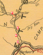
[2][7] Proctor, as it is now known, is 1.66 miles (2.67 km) north of Barbours along Plunketts Creek,[8] and the main road to it crossed the bridge.
[2] Finished sole leather was hauled over the bridge by horse-drawn wagon south about 8 miles (13 km) to Little Bear Creek, where it was exchanged for "green" hides and other supplies brought north from Montoursville.
Hemlock bark, used in the tanning process, was hauled to the tannery from up to 8 miles (13 km) away in both summer and winter, using wagons and sleds.
By 1898, the old-growth hemlock was exhausted and the Proctor tannery, then owned by the Elk Tanning Company, was closed and dismantled.
In 1931, the Commonwealth of Pennsylvania passed legislation that gave the state responsibility for the costs of road and bridge maintenance for many highways belonging to local municipalities.
[9][10] In the 1980s, the last store in Barbours closed, and the former hotel (which had become a hunting club) was torn down to make way for a new bridge across Loyalsock Creek.
[6] Plunketts Creek has been a place for lumber and tourism since its villages were founded, and as industry declined, nature recovered.
[2][12] The main entrance to State Game Lands 134 is just north of the bridge site, on the east side of the creek.
[14] The Northcentral State Game Farm is chiefly in the Plunketts Creek valley, just south of Proctor and north of the bridge.
[2][13] The opening weekend of the trout season brings more people into the village of Barbours at the mouth of Plunketts Creek than any other time of the year.
The MPS included 135 bridges owned by the Pennsylvania Department of Transportation (PennDOT), 58 of which were of the stone arch type.
The 1995–1996 early winter was unusually cold, and considerable ice buildup formed in local streams.
[18] On Plunketts Creek, ice jams led to record flooding, which caused irreparable major damage to the mid-19th century stone arch bridge.
"[19] In neighboring Sullivan County, the Sonestown Covered Bridge, also on the NRHP, was so damaged by the flood that it remained closed for repairs until late December 1996.
[20] Throughout Pennsylvania, these floods led to 20 deaths and 69 municipal- or state-owned bridges being either "destroyed or closed until inspections could verify their safety".
Then the road bed was built, with fill (loose stones or dirt) added to support it as needed.