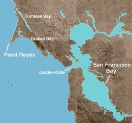
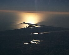
Point Reyes
Seasonal hunters and gatherers, they were nourished by fish, clams, mussels, and crab, in addition to the deer, elk, bear, mud hen, geese, and small game they hunted with spears and bows.
While attempting to convert them, these missionaries introduced diseases that brought many deaths, fewer births, and significantly increasing infant mortality rates.
The tribe has almost 500 members,[4] who engage in a revival of traditional customs and ceremonies, often held in Kule Loklo, "Valley of the Bear", a replica Miwok village in Point Reyes National Seashore.
[6] On November 13, 1542, Spanish explorer Juan Rodríguez Cabrillo sighted and named "Cabo de Pinos" (Point Reyes), but missed the entrance to San Francisco Bay, a lapse that mariners would repeat for the next two centuries and more, due to the fog that characterizes the area.
These notes describe the genial welcome Drake and his men received, complete with ceremony and gifts, as well as the landscape and wildlife, and included commentary about fog which frequently obscures the peninsula during the summer months.
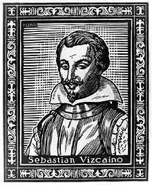
Many believe that Drake's discovery of such a harbor inspired the Spanish to order Sebastian Rodriguez Cermeno, a Portuguese captain trading for Spain, to survey the California coast on his journey to Mexico from the Philippines in 1595.
Commanding San Agustin, a Manila galleon laden with a luxury cargo of Chinese silks, spices, and Ming porcelain bound for Acapulco, Cermeno endured both the first of hundreds of documented shipwrecks at Point Reyes, as well as one of the most amazing journeys to safety.
[10] Struggling with a decrepit, heavily laden ship and a tired crew, Cermeno explored the California coast, eventually anchoring near the Point Reyes inlet now called Drakes Estero.
[9][page needed] Cermeno salvaged a small, open launch, likened to a large canoe, and loaded it with the 70 surviving crew members to begin the long journey home.
Despite his amazing journey, Cermeno received no celebratory welcome, for he had not only lost his ship and cargo, but had also failed to locate the safe harbor he was ordered to find.
[9][page needed] When the Spanish missions in California were dismantled, virtually all of Point Reyes was given to 'Rafael Garcia, a corporal in the Mexican Army, who was awarded two leagues (8,911 acres (3,606 ha)) in March 1836.
Garcia's failure to survey and confirm boundaries, as required by Mexican law, set the stage for confusion and lengthy court battles when the rancho was dissolved.
Unfortunately for Garcia, these gold-rich years ended quickly: in 1851, the United States passed a law requiring rancheros to prove legal ownership of their land grants.
A mere two years later, Berry sold nearly 9,000 acres (3,642 ha) of it to a sea captain, Joseph Snook, an act clearly prohibited by Mexican law and grounds for forfeiture of the entire grant.
Little was clarified, and it was not until the United States took possession of California and required rancheros to conduct surveys and make court appearances to retain their land that the confusing pattern of sales and trades were untangled.
With cash in hand, they purchased these huge Mexican land grants, often paying less than $2 per acre, thus beginning Point Reyes's next chapter as a dairying empire.
A Vermont lawyer intent upon making his fortune and returning home as soon as possible, he left his family to journey to booming San Francisco.
When Oscar's oldest daughter married Charles Webb Howard, also a lawyer, the trio partnered to transform windswept Point Reyes into prosperous dairies.
During Spanish and Mexican War, Bolinas' remote lagoon was used by American, British, and Russian smugglers intent on avoiding tariffs and regulations.
[citation needed] Later, when the Gold Rush of 1849 generated a huge market for lumber, Bolinas became the port for nearby timber operations and, briefly, quarrying limestone.
In 1971, they succeeded in scrapping a master plan calling for a population of 28,000 by imposing a moratorium on new homes and defeating efforts to widen its access highway.
[citation needed] Within three years, it had emerged as the region's commercial center with a post office, grocery store, saloon, butcher, livery stable, and two hotels.
[13] While this Olema chapter of the United Ancient Order of Druids adhered to principles of mutual support, intellectual growth, and social consciousness, it also served as a temperance society.
[15] In cooperation with the NPS, volunteers have restored and maintain a historic coastal radiotelegraph marine station, KSM (ex-KPH), at Point Reyes.
[17] In 1874 American whaleman Charles Melville Scammon recorded in Marine Mammals of the Northwestern Coast of America, that "the elephant seal...known to the Old Californians as Elefante marino had a geographical distribution from Cape Lazaro (about 1/4 of the way up the Baja peninsula) in the south to Point Reyes in the north".
The first breeding pair was discovered on a sheltered beach below Point Reyes' Chimney Rock in 1981 and has multiplied at a remarkable 16% per year to the present population of 1,500 to 2,000 individuals each winter.
[25] Half of the ten Point Reyes dairy cattle herds were infected with paratuberculosis (aka Johne's Disease) along with exotic deer in a 1977 study.
In 2006, the park embarked on a plan to eradicate the non-native deer via contraception and culling, which succeeded despite controversy, over a twenty year program.
[31] Vegetation native to Point Reyes includes bishop pine, Douglas-fir, coyote brush, monkeyflower, poison oak, California blackberry, salal and coast redwood, among others.
[33] The peninsula is a member of the Salinian Block, a segment of the southernmost Sierra Nevada range transported north from Southern California by movement along the San Andreas fault.