Polk County, North Carolina
It was named for William Polk, a colonel in the American Revolutionary War.
Lake Adger is a reservoir formed by the damming of the Green River, which flows from west to east across the county.
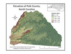
The elevation in the county ranges from just under 800 feet (240 m) near the confluence of the Green River and Broad River to over 3,200 feet (980 m) on Tryon Peak and Wildcat Spur, the highest peak in the county.
Since it is in a transition zone between the two regions, Polk County is often referred to as being in the foothills.
Interstate 26 provides Polk County with access to Asheville and Spartanburg, South Carolina.
This was the primary highway linking Saluda and Tryon to Hendersonville and Spartanburg, SC.
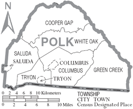
NC 108 begins in Rutherfordton and travels west through Columbus and ends at US 176 in Tryon.
Oriented north-to-south, NC 9 connects Black Mountain and Lake Lure to Spartanburg and points southeast via Polk County.
[6] Norfolk Southern suspended freight traffic indefinitely along this route in December 2001.
28.90% of all households were made up of individuals, and 15.00% had someone living alone who was 65 years of age or older.