Pop-up satellite archival tag
Pop-up satellite archival tags (PSATs) are used to track movements of (usually large, migratory) marine animals.
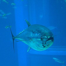
They have been used to track movements of ocean sunfish,[1] marlin, blue sharks, bluefin tuna, swordfish and sea turtles to name a few species.
The first method is through light based geolocation which uses the length of the day and a noon time calculation to estimate the tags location while underwater.
When the PSAT releases from the animal on which it was attached, it floats to the surface, and begins to transmit data to the Argos satellites at a frequency of 401.65 MHz +/-.
Most PSATS have internal software designed to detect damaging or sub-optimal conditions that will trigger an early release and transmission of data.
[4] The most popular method of determining an animal's location underwater requires the tag to acquire light levels throughout the day.
From the length of day the tag computes the noon time which is converted to a longitude location (with accuracy averaging about 0.5 degree or 30–50 nautical miles).
This method measures the total Earth's magnetic field for latitude estimations while using light based noon time detection for longitude.