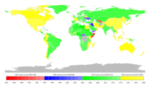
Population and housing censuses by country
[1] Complications to carrying out a census include tribal conflict, war, borders not demarcated, budget, inexperience, political snags, lack of manpower, and poor geographic information systems.
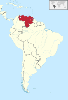
[3] General censuses of population and housing (Portuguese: Recenseamento Geral da População e Habitação (RGPH)) have been carried out in 1970 and 2014.
[20] The Cape of Good Hope conducted the first modern scientific census in 1865, following the principles laid down by the British Colonial Office and repeated the exercise in 1875 and 1891.23 The Orange Free State followed in 1880 and 1890, copying many of the features of the Cape of Good Hope.24 The South African Republic (Transvaal) followed in 1890.However, the enumeration was restricted to the White population.
The establishment of the Union of South Africa as a British dominion in 1910 necessitated a new start to enumeration in the country and the statistical definition of the new state and ordering of its population through the census.
It covered several topics including: population and housing; agriculture; and Micro- and small Enterprises administered at individual/household level.
Its hierarchies include: Brazil (Country), Major Regions, States, Macro-regions, micro-regions, municipalities, districts, sub-districts, Neighborhoods and census tracts.
In 1871, Canada's first formal census was conducted, which counted the population of Nova Scotia, Ontario, New Brunswick, and Quebec.
At a sub-national level, two provinces (Alberta and Saskatchewan) and two territories (Nunavut and Yukon) have legislation that allows local governments to conduct their own municipal censuses.
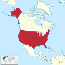
From 1950 onward, census forms were mailed to every address on record with the United States Post Office, including the Armed Services Postal System, in an effort to enhance completeness of the data collected.
Next census was scheduled to begin 1 April 2020[56][circular reference] but delays due to the ongoing COVID-19 pandemic meant most areas did not assign enumerators and begin counting until after August 1, 2020, even while their questions are still written to tabulate information about a housing unit's status on the prior date.
[60][5] Wars since then have caused significant population displacement and there has not been an updated count nor does the nation seem to have the technical ability nor will to tackle a modern census.
They collect data related to households e.g. number of members, water & electricity supply, ownership of land, vehicles, computers and other assets and services.
In the second phase, total population is counted and statistics related to individuals are collected and saved into the governments hand.
[75]: 135 They solicit information such as name, gender, relationship to head of household, year and month of birth, marital status, nationality, number of the household members, type and tenure of dwelling, floor area of the dwelling, number of hours worked during the week prior to October 1, employment status, name of employer and type of business, kind of work, and the place of work or schooling.
Tokyo was chosen as the initial rollout for the online questionnaires due to the high concentration of people living in apartment buildings or gated communities, which restricts the access of census workers.
The first official census in the Philippines was carried out by the Spanish government pursuant to a royal decree calling for the counting of persons living as of the midnight of December 31, 1877.
The data provided in the Bulgarian censuses from 1888 until World War II is regarded as highly reliable[citation needed] according to the standards of the time.
The Bulgarian leading statisticians of the period were generally educated in Western universities and participated vividly in the international cooperation, therefore insisted and succeeded in introducing the best practices of the time.
Following these early undertakings, the first census to attempt completely covering all citizens (including women and children who had previously been listed only as numbers) of Denmark-Norway was taken in 1769.
The latter also included territories of modern-day Latvia, however its Estonian-populated counties of Võru, Tartu, Viljandi, Pärnu and Saaremaa roughly corresponded to the later borders of the Republic of Estonia.
The 1959, 1979 and 1989 censuses were carried out by the Estonian SSR of the Soviet Union and excluded Jaanilinn and Petseri County, which were annexed by the Russian SFSR in 1945.
The first systematic population on the European continent was taken in 1719 in Prussia (roughly corresponding to today's northern Germany and western Poland).
Attempts at introducing a census in West Germany sparked strong popular resentment in the 1980s since many quite personal questions were asked.
[106] Official decennial censuses have been taken in Hungary since 1870; the latest one – in line with the recommendations of the United Nations and the Statistical Office of the European Union – was carried out in 2011.
The 1703 exercise was the first census ever to cover all inhabitants of an entire country, mentioning the name, age, and social position of each individual.
The need for censuses was eliminated through the setting up, in 1952, of the National Registry (Þjóðskrá), which later merged with other entities to form Registers Iceland.
[125][126] The Ufficio Informatica, Tecnologia, Dati e Statistica conducted the sixth population census on 7 November 2010.
In Switzerland, the Federal Population Census (German: Eidgenössische Volkszählung, French: Recensement fédéral de la population, Italian: Censimento federale della popolazione, Romansh: Dumbraziun federala dal pievel) has been carried out every 10 years starting in 1850.
[citation needed] The Domesday Book of 1086 in England contained listings of households but its coverage was not complete and its intent was not the same as modern censuses.
Following the influence of Malthus and concerns stemming from his An Essay on the Principle of Population the UK census as we know it today started in 1801.